Click to visit the main New York Public Library Homepage
The New York Public Library
Digital Collections
About Digital Collections
Browse
Search only public domain materials
Items
Collections
Divisions
Home
Search
Browse
About
Search only public domain materials
Items
Collections
Divisions
Digital Collections
Using Images
Using Data
Collections
Atlases of the United States
Atlases of the United States
Navigation
About
Filters
Atlases of the United States
Previous
United States
42
Indiana
1
Kentucky
2
Maryland
1
New Jersey
910
New York
2887
Wisconsin
23
Michigan
2
More
Collection Data
Description
The Map Division's collection of historical atlases of the United States, showing states, counties, and cities. Includes fire insurance, cadastral, geological, and pictorial maps, dating largely from the 19th and early 20th centuries.
Library locations
Lionel Pincus and Princess Firyal Map Division
Topics
United States
Genres
Atlases
Maps
Type of Resource
Cartographic
Identifiers
Universal Unique Identifier (UUID): 2600a3f0-c5ec-012f-424e-58d385a7bc34
Show filters
Hide filters
Show Only Public Domain
topic
x
Real property
Business enterprises
116
History
90
Description and travel
45
name
x
Beers, F. W. (Frederick W.)
J.B. Beers & Co
62
Walker & Jewett (Firm)
62
Cramer, Louis H
28
Sanford, G. P. (George P.)
26
collection
x
Atlases of the United States
place
New York (State)
249
Orange County
90
Orange County (N.Y.)
90
Cayuga County
62
Cayuga County (N.Y.)
62
More
Less
genre
Atlases
294
Maps
205
Prints
53
Title pages
3
publisher
Andreas, Baskin & Burr
90
Walker & Jewett
62
J.B. Beers
28
Beers, Ellis & Soule
26
division
Map Division
294
type
cartographic
257
text
37
still image
1
Date Range
to
294 results found
Filtering on:
x
Name
: Beers, F. W. (Frederick W.)
x
Topic
: Real property
Sort by:
Title
Date created
Date digitized
Sequence
Atlas of Monmouth co., New Je…
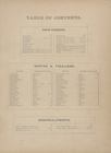
Table of Contents.
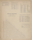
Explanations for the Atlas ; …
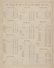
The Census of the States of N…
The Census of the States of N…
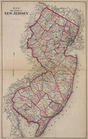
Map of The State of New Jersey
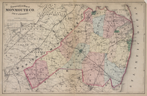
Topographical Map of Monmouth…
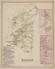
Matawan Business Notices. ; M…
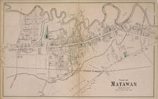
Plan of Matawan [Village]
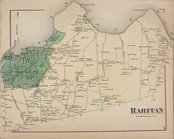
Raritan [Township]
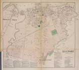
Keyport [Village]; Keyport Bu…
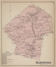
Marlboro Business Notices. ; …
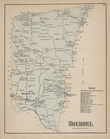
Holmdel Business Directory. ;…
Holmdel [Village]; Marlboro […
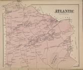
Atlantic [Township]
Highlands [Village]; Middleto…
Navesink [Village]; Parkervil…
Redbank Business Directory. ;…
Long Beach Business Notices. …
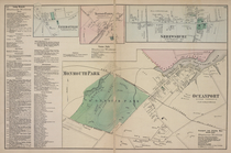
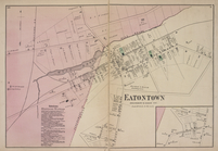
Eatontown Business Notices. ;…
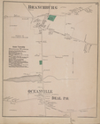
Branchburg [Village]; Ocean T…
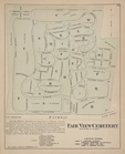
Fair View Cemetery [Village]
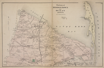
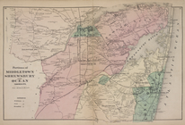
Portions of Middletown and Oc…
Portions of Middletown, Shrew…
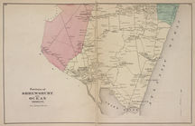
Portions of Shrewsbury and Oc…
Seabright & Monmouth Beach Pr…
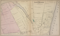
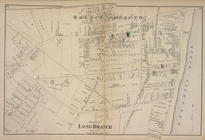
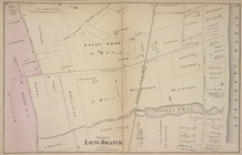
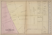
Portion of Long Branch [Villa…
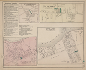
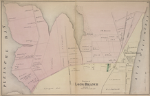
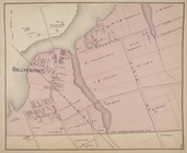
Branchport [Village]
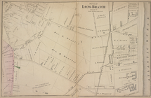
Portion of Long Branch [Villa…
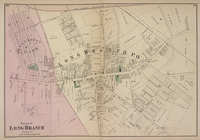
Portion of Long Branch [Villa…
Portion of Long Branch [Villa…
Portion of Long Branch [Villa…
Portion of Long Branch [Villa…
Portion of Long Branch [Villa…
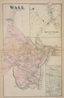
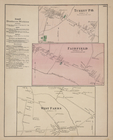
Wall [Township]; Squan Villag…
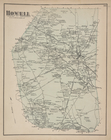
Howell [Township]
Howell Business Notices. ; Je…
Howell Business Notices. ; Tu…
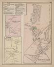
Freehold [Township]; Freehold…
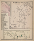
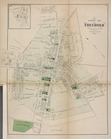
Town of Freehold [Village]
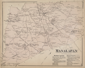
Manalapan [Township]; Manalap…
Blacks Mills [Village]; Mills…
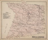
Millstone [Township]; Millsto…
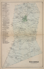
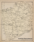
Upper Freehold [Township]
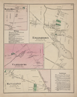
Allentown [Village]; Ellisdal…
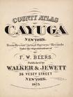
County Atlas of Cayuga New Yo…
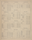
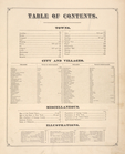
Table of Contents
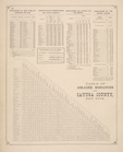
Table of Air-Line Distances f…
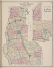
Map of Cayuga County New York…
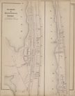
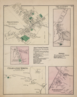
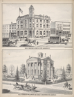
Cor. of Genesee & South Str's…
1
2
Previous
Next
1
2
Previous
Next