


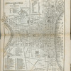
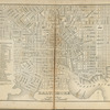


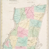
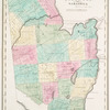
![Brasher [Township]](https://images.nypl.org/index.php?id=1601918&t=b)
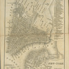
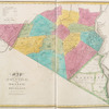
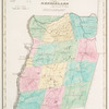
![Canton [Township]](https://images.nypl.org/index.php?id=1601919&t=b)
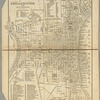
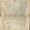
![Canton Village Directory. ; Canton [Village]](https://images.nypl.org/index.php?id=1601920&t=b)
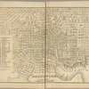
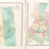
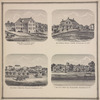
![Brasher Falls [Village]; Brasher Business Directory. ; Brasher Iron Works [Village]; Brasher Iron Works Business Directory. ; Rensselear Falls [Village]; Rensselear Falls Directory. ; Morley [Village]; Morley Village Business Directory. ; Helena [Village]; Helena Business Directory.](https://images.nypl.org/index.php?id=1601921&t=b)
![Colton Business Directory. ; Part of Colton including the original Township of Matildaville and a part of Parishville including the original Township of Wick [Townships]; Colton [Village]](https://images.nypl.org/index.php?id=1601922&t=b)
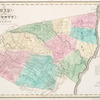
![Dekalb [Village]; Dekalb Business Directory. ; Dekalb [Township]](https://images.nypl.org/index.php?id=1601923&t=b)
![Heuvelton [Village]; Heuvelton Business Directory. ; Nicholville [Village]; Nicholville Business Directory.](https://images.nypl.org/index.php?id=1601924&t=b)
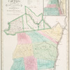
![Depeyster [Village]; De Peyster Business Directory. ; De Peyster [Township]](https://images.nypl.org/index.php?id=1601925&t=b)
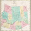
![Edwards [Village]; Edwards Business Directory. ; Edwards [Township]](https://images.nypl.org/index.php?id=1601926&t=b)
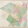
![Part of Fine comprising Scruba and part of Sarahsburgh [Township]; Fine Business Directory.](https://images.nypl.org/index.php?id=1601927&t=b)
- The Library Shop
- Privacy Policy
- Rules and Regulations
- Using the Internet
- Website Terms and Conditions
- Gifts of Materials to NYPL
-
© The New York Public Library, 2025
The New York Public Library is a 501(c)(3) | EIN 13-1887440
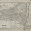
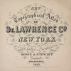
New topographical atlas of St. Lawrence County, N.Y. : from actual surveys
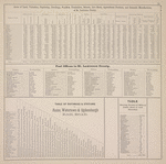
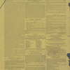
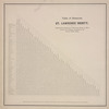
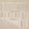
Lionel Pincus and Princess Firyal Map Division, The New York Public Library. "Acres of Land, Valuation, Population, Dwellings, Families, Freeholders, Schools, Live Stock, Agricultural Products, and Domestic Manufactures of St. Lawrence County. ; Post Offices in St. Lawrence County. ; Table of Distances & Stations on Rome, Watertown & Ogdensburgh Rail Road. ; Table showing Number of Miles of Public Road in each Township." The New York Public Library Digital Collections. 1865. https://digitalcollections.nypl.org/items/510d47e3-b08c-a3d9-e040-e00a18064a99
Lionel Pincus and Princess Firyal Map Division, The New York Public Library. "Acres of Land, Valuation, Population, Dwellings, Families, Freeholders, Schools, Live Stock, Agricultural Products, and Domestic Manufactures of St. Lawrence County. ; Post Offices in St. Lawrence County. ; Table of Distances & Stations on Rome, Watertown & Ogdensburgh Rail Road. ; Table showing Number of Miles of Public Road in each Township." New York Public Library Digital Collections. Accessed March 14, 2025. https://digitalcollections.nypl.org/items/510d47e3-b08c-a3d9-e040-e00a18064a99
Lionel Pincus and Princess Firyal Map Division, The New York Public Library. (1865). Acres of Land, Valuation, Population, Dwellings, Families, Freeholders, Schools, Live Stock, Agricultural Products, and Domestic Manufactures of St. Lawrence County. ; Post Offices in St. Lawrence County. ; Table of Distances & Stations on Rome, Watertown & Ogdensburgh Rail Road. ; Table showing Number of Miles of Public Road in each Township. Retrieved from https://digitalcollections.nypl.org/items/510d47e3-b08c-a3d9-e040-e00a18064a99
<ref name=NYPL>{{cite web | url=https://digitalcollections.nypl.org/items/510d47e3-b08c-a3d9-e040-e00a18064a99 | title=
(cartographic)
Acres of Land, Valuation, Population, Dwellings, Families, Freeholders, Schools, Live Stock, Agricultural Products, and Domestic Manufactures of St. Lawrence County. ; Post Offices in St. Lawrence County. ; Table of Distances & Stations on Rome, Watertown & Ogdensburgh Rail Road. ; Table showing Number of Miles of Public Road in each Township., (1865)
|author=Digital Collections, The New York Public Library |accessdate=March 14, 2025 |publisher=The New York Public Library, Astor, Lenox, and Tilden Foundations}}</ref>