


![Plate 4: [Bounded by Pomeroy Street, Jackson Avenue, Nott Avenue, Creek Street, Borden Avenue, West Avenue, Flushing Street, Front Street, Fifth Street, West Avenue, Nott Avenue, Vernon Avenue, Sanford Street, Sherman Street, Pierce Avenue, Lockwood Avenue and Webster Avenue.]](https://images.nypl.org/index.php?id=1523074&t=b)
![Plate 5: [Bounded by Dickinson Street, Woodside Avenue, Calvary Cemetery Road, Borden Avenue, Greenpoint Avenue, (Calvary Cemetery) Bradley Avenue, Review Avenue, Bradley Avenue, Orton Street, Nott Avenue and Jackson Avenue.]](https://images.nypl.org/index.php?id=1523075&t=b)
![Plate 6: [Bounded by Franklin Street, Flushing Avenue, Old Bowery Bay Blvd., Jackson Avenue, Western Avenue, Lockwood Avenue, Pierce Avenue, Sherman Street, Broadway, Boulevard, Fulton Street and Mills Street.]](https://images.nypl.org/index.php?id=1523076&t=b)
![Plate 7: [Bounded by Berrians Avenue, De Bevoise Avenue, Riker Avenue, Old Bowery Road, Cabinet Street, Flushing Avenue, Mills Street, Orchard Street, Remsen Street and Boulevard.]](https://images.nypl.org/index.php?id=1523077&t=b)
![Plate 8: [Bounded by Hillside Ave., Union Ave., Highland Ave., Grand St., Warwick Ave., Warwick Crescent, King St., Madison St., Fulton St., Wheeleer Ave., South St., George St., Sayres St., Merrick & Jamaica Plank Rd., South St., Jay St., Humboldt Blvd., Wyckoff Street, Liberty Ave., Guilford St., Chichester Ave., Kensington Ave., Johnston Ave., Rockway Tpke., Fulton St. & Hoffman Blvd.]](https://images.nypl.org/index.php?id=1523078&t=b)
![Plate 9: [Bounded by Lawrence Avenue, Bayside Avenue, Congress Avenue, Myrtle Avenue, Whitestone Avenue, Bayside Avenue, Murray Avenue, Sanford Avenue, Parsons Avenue, Laburnum Avneue, Bowne Avenue, Oak Avenue, Jamaica Avenue, Mulberry Street, Colden Avenue, Franklin Pl., Summit Street, Bank Street.]](https://images.nypl.org/index.php?id=1523079&t=b)
![Plate 10: [Bounded by Intersection Street, Franklin Street, Stevens Avenue, Main Street, Columbia Street, Stewart Avenue, Bennett Avenue, Fulton Street, William Street, Gerard Street, Greenwich Street, Grove Street, Prospect Street, Franklin Street, Front Street, Fulton Street, Cathedral Avenue, Atlantic Street and Cedar Valley Street.]](https://images.nypl.org/index.php?id=1523080&t=b)
![Plate 11: [Bounded by Bay Avenue, Franklin Avenue, Ocean Avenue, Healey Avenue, Bayview Avenue, The Strand, Bay Street, Mott Avenue, Grand Avenue, Crescent Place, Bay Street, Mott Avenue, Bay view Terrace, Cedar Avenue, Mott Avenue, Central Avenue, John Street, Wave Crest Avenue, and Bay Avenue.]](https://images.nypl.org/index.php?id=1523081&t=b)
![Plate 12: [Bounded by Central Avenue, Boulevard, Horton Avenue, Remsen Avenue, Mc Neil Avenue, Central Avenue, Lord Avenue, Greenwood, Jarvis Avenue, Cedar Hill Avenue, Fenwick Avenue, Somerset Avenue, Cedar Hill Avenue, Oak Street, Greenwood, Rue De. St. Felix, Coster Street and South Street.]](https://images.nypl.org/index.php?id=1523082&t=b)
![Plate 13: [Bounded by Rockaway Beach Boulevard, Averne Boulevard,... (Atlantic Ocean, Jamaica Bay), Eldert Avenue, Rockaway Beach Boulevard, Eastern Avenue, Triton Avenue and Tenth Avenue.]](https://images.nypl.org/index.php?id=1523083&t=b)
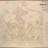
![Atlas of the Borough of Queens. City of New York complete in Three Volumes. Volume Two, First and Second Wards. Long Island City and Newtown. [Title page]](https://images.nypl.org/index.php?id=1693987&t=b)
![Queens, Vol. 2, Double Page Plate No. 1; Part of Long Island City Ward One (Part of Old Ward One); [Map bounded by Division St., Vernon Ave., 12th St., Ely Ave., Jackson Ave., Thomson Ave., Nott Ave., Creek St., Dutch Kill Creek, Newtown Creek; Including Front St., River St., Pier St., Dock St., Pidgeon St., Flushing St., Borden Ave., 3rd St., 4th St., 5th St., 6th St., 7th St., 8th St., 9th St., 10th St., 11th St.]; Sub Plan; [Map bounded by Pier St., River St.; Including Front St., Newtown Creek]](https://images.nypl.org/index.php?id=1693991&t=b)
![Queens, Vol. 2, Double Page Plate No. 2; Part of Long Island City Ward One (Part of Old Wards One and Three); [Map bounded by Prospect St., Harris Ave., Jackson Ave., 12th St., Vernon Ave., Division St., West Ave., Nott Ave., 13th St., 14th St., Englis St.; Including Bodine St., Harris Ave., Wallach St., Charles St., Babbett St., Harsell St., Worth St., Noble St., Judson St., Freeman Ave., Park PL., Webster Ave.]](https://images.nypl.org/index.php?id=1693992&t=b)
![Queens, Vol. 2, Double Page Plate No. 3; Part of Long Island City Ward One (Part of Old Wards Two, Three and Four); [Map bounded by Van Pelt St., Nott Ave., Creek St., Meadow St., Purves St., Hunter Ave., Prospect St.; Including Webster Ave., Radde St., Washington Ave., Pomeroy St., Jackson Ave.]; Sub Plan ; [Map bounded by Purvis Ave., Nott Ave.; Including Thomson Ave.]](https://images.nypl.org/index.php?id=1693993&t=b)
![Queens, Vol. 2, Double Page Plate No. 4; Part of Long Island City Ward One (Part of Old Wards One and Two); [Map bounded by Van Pelt St., Greenpoint Ave., Hunters Point Ave., Borden Ave., Bradlay Ave.; Including Newtown Creek, Water St., Proposed Canal (Dutch Kills Creek),Creek St., Nott Ave.]; Sub Plan; [Map bounded by Marsh St., Water St.; Including Proposed Canal]](https://images.nypl.org/index.php?id=1693994&t=b)
![Queens, Vol. 2, Double Page Plate No. 5; Part of Long Island City Ward One (Part of Old Ward Two) and Part of Newtown Ward Two; [Map bounded by Woodside Ave., Celtic Ave. (Highway to Calvary Cemetery), Hunters Point Ave.; Including Borden Ave., Van Pelt St., Middleburg Ave.]](https://images.nypl.org/index.php?id=1693995&t=b)
![Queens, Vol. 2, Double Page Plate No. 6; Part of Long Island City Ward One (Part of Old Wards Two and Four); [Map bounded by Jamaica Ave., Old Bowery Bay Road, Woodside Ave., Middleburg Ave., Van Buren St., Lowery St.; Including Bragaw St., Harold St., Jackson Ave., Pomeroy St., Washington Ave., Rapelje Ave.]; Sub Plan; [Map bounded by Van Pelt St., Harold St., Bragaw St.; Including Lowery St., Van Buren St., Middleburg Ave.]](https://images.nypl.org/index.php?id=1693996&t=b)
![Queens, Vol. 2, Double page plate No. 7; Part of Long Island City Ward One (Part of Old Wards Three and Four); [Map bounded by Jamaica Ave., Rapelje Ave. (4th Ave.), Washington Ave., Webster Ave.; Including Rutledge St., Graham Ave., Vernon Ave., Boulevard]](https://images.nypl.org/index.php?id=1693997&t=b)
![Queens, Vol. 2, Double Page Plate No. 8; Part of Long Island City Ward One ( Part of Old Wards Four and Five); [Map bounded by Boulevard, Emily Terrace, Edmard St., Barclay St., Woolsey Ave., De Bevoise Ave. (Bradford St.), Jamaica Ave., Fulton Ave.; Including Mills St. (1st St.), Orchard St., Munson St., Halsey St., Perrot PL., Wardell St., Remsen St., Woolsey St., Hoyt Ave.]](https://images.nypl.org/index.php?id=1693998&t=b)
![Queens, Vol. 2, Double Page Plate No. 9; Part of Long Island City Ward One (Part of Old Wards Four and Five); [Map bounded by Albert St., Theodore St., Sound St., Purdy St., Flushing Ave.; Including Old Bowery Bay Road, Jamaica Ave., Debevoise Ave., Woolsey Ave., Steinway Ave.]](https://images.nypl.org/index.php?id=1693965&t=b)
![Queens, Vol. 2, Double Page Plate No. 10; Part of Long Island City ward One (Part of Old Ward Five); [Map bounded by Winthrop Ave., Albert St., Flushing Ave.; Including Woolsey Ave., Boulevard]](https://images.nypl.org/index.php?id=1693966&t=b)
![Queens, Vol. 2, Double Page Plate No. 11; Part of Long Island City Ward One (Part of Old Ward Five); [Map bounded by Old Bowery Bay Road, Flushing Ave., Potter Ave., Albert St., Winthrop Ave., Rapelje St.; Including Proposed Canal, Berrians Creek, Berrian Ave., Bowery Bay, Riker Ave.]; Sub Plan; [Map bounded by Blackwell St., Debevoise Ave., Lawrence St., Chauncey St.; Including Goodrich St., Merchant St., Berrian Ave.]](https://images.nypl.org/index.php?id=1693967&t=b)
- The Library Shop
- Privacy Policy
- Rules and Regulations
- Using the Internet
- Website Terms and Conditions
- Gifts of Materials to NYPL
-
© The New York Public Library, 2025
The New York Public Library is a 501(c)(3) | EIN 13-1887440
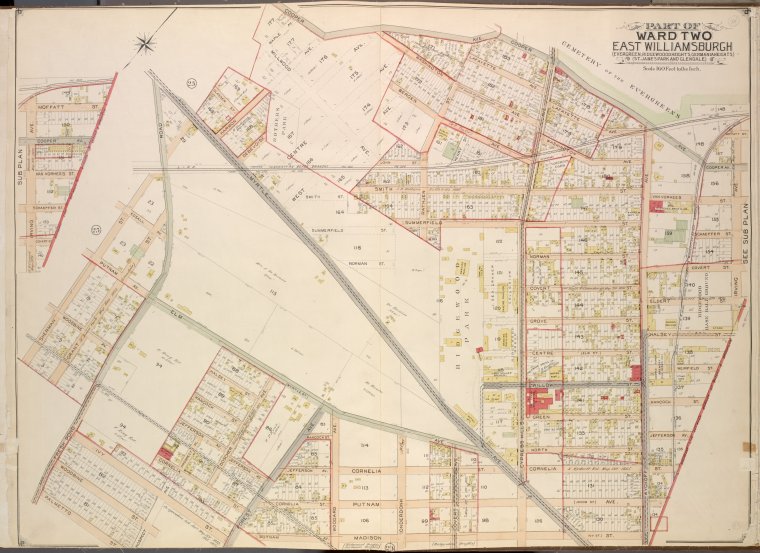
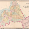
![Queens, Vol. 2, Double Page Plate No. 24; Part of Ward Two East Williamsburgh (Evergreen, Ridge Woodheights, Germaniaheights), (St. James Park and Glendale); [Map bounded by Cooper Ave., Irving Ave., Boundary Line between Borough of Queens and Brooklyn, Madison St., Putnam Ave., Prospect Ave.; Including Palmetto St., Fresh Pond Road, Grant St., Sherman St., Myrtle Ave., Glasser St.]; Sub Plan; [Map bounded by Irving Ave., Moffalt St., Cooper Ave., Van Vorhees St.; Including Schaeffer St., Covert St., Boundary Line between borough of Queens and Brooklyn](https://images.nypl.org/index.php?id=1693980&t=b)
Lionel Pincus and Princess Firyal Map Division, The New York Public Library. "Queens, Vol. 2, Double Page Plate No. 24; Part of Ward Two East Williamsburgh (Evergreen, Ridge Woodheights, Germaniaheights), (St. James Park and Glendale); [Map bounded by Cooper Ave., Irving Ave., Boundary Line between Borough of Queens and Brooklyn, Madison St., Putnam Ave., Prospect Ave.; Including Palmetto St., Fresh Pond Road, Grant St., Sherman St., Myrtle Ave., Glasser St.]; Sub Plan; [Map bounded by Irving Ave., Moffalt St., Cooper Ave., Van Vorhees St.; Including Schaeffer St., Covert St., Boundary Line between borough of Queens and Brooklyn" The New York Public Library Digital Collections. 1903. https://digitalcollections.nypl.org/items/63226e55-ebd5-159d-e040-e00a1806318b
Lionel Pincus and Princess Firyal Map Division, The New York Public Library. "Queens, Vol. 2, Double Page Plate No. 24; Part of Ward Two East Williamsburgh (Evergreen, Ridge Woodheights, Germaniaheights), (St. James Park and Glendale); [Map bounded by Cooper Ave., Irving Ave., Boundary Line between Borough of Queens and Brooklyn, Madison St., Putnam Ave., Prospect Ave.; Including Palmetto St., Fresh Pond Road, Grant St., Sherman St., Myrtle Ave., Glasser St.]; Sub Plan; [Map bounded by Irving Ave., Moffalt St., Cooper Ave., Van Vorhees St.; Including Schaeffer St., Covert St., Boundary Line between borough of Queens and Brooklyn" New York Public Library Digital Collections. Accessed February 7, 2025. https://digitalcollections.nypl.org/items/63226e55-ebd5-159d-e040-e00a1806318b
Lionel Pincus and Princess Firyal Map Division, The New York Public Library. (1903). Queens, Vol. 2, Double Page Plate No. 24; Part of Ward Two East Williamsburgh (Evergreen, Ridge Woodheights, Germaniaheights), (St. James Park and Glendale); [Map bounded by Cooper Ave., Irving Ave., Boundary Line between Borough of Queens and Brooklyn, Madison St., Putnam Ave., Prospect Ave.; Including Palmetto St., Fresh Pond Road, Grant St., Sherman St., Myrtle Ave., Glasser St.]; Sub Plan; [Map bounded by Irving Ave., Moffalt St., Cooper Ave., Van Vorhees St.; Including Schaeffer St., Covert St., Boundary Line between borough of Queens and Brooklyn Retrieved from https://digitalcollections.nypl.org/items/63226e55-ebd5-159d-e040-e00a1806318b
<ref name=NYPL>{{cite web | url=https://digitalcollections.nypl.org/items/63226e55-ebd5-159d-e040-e00a1806318b | title=
(cartographic)
Queens, Vol. 2, Double Page Plate No. 24; Part of Ward Two East Williamsburgh (Evergreen, Ridge Woodheights, Germaniaheights), (St. James Park and Glendale); [Map bounded by Cooper Ave., Irving Ave., Boundary Line between Borough of Queens and Brooklyn, Madison St., Putnam Ave., Prospect Ave.; Including Palmetto St., Fresh Pond Road, Grant St., Sherman St., Myrtle Ave., Glasser St.]; Sub Plan; [Map bounded by Irving Ave., Moffalt St., Cooper Ave., Van Vorhees St.; Including Schaeffer St., Covert St., Boundary Line between borough of Queens and Brooklyn, (1903)
|author=Digital Collections, The New York Public Library |accessdate=February  7, 2025 |publisher=The New York Public Library, Astor, Lenox, and Tilden Foundations}}</ref>
![Queens, Vol. 2, Double Page Plate No. 24; Part of Ward Two East Williamsburgh (Evergreen, Ridge Woodheights, Germaniaheights), (St. James Park and Glendale); [Map bounded by Cooper Ave., Irving Ave., Boundary Line between Borough of Queens and Brooklyn, Madison St., Putnam Ave., Prospect Ave.; Including Palmetto St., Fresh Pond Road, Grant St., Sherman St., Myrtle Ave., Glasser St.]; Sub Plan; [Map bounded by Irving Ave., Moffalt St., Cooper Ave., Van Vorhees St.; Including Schaeffer St., Covert St., Boundary Line between borough of Queens and Brooklyn](https://images.nypl.org/index.php?id=1693980&t=t)