


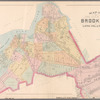
![Plate 4: [Bounded by Pomeroy Street, Jackson Avenue, Nott Avenue, Creek Street, Borden Avenue, West Avenue, Flushing Street, Front Street, Fifth Street, West Avenue, Nott Avenue, Vernon Avenue, Sanford Street, Sherman Street, Pierce Avenue, Lockwood Avenue and Webster Avenue.]](https://images.nypl.org/index.php?id=1523074&t=b)
![Plate 5: [Bounded by Dickinson Street, Woodside Avenue, Calvary Cemetery Road, Borden Avenue, Greenpoint Avenue, (Calvary Cemetery) Bradley Avenue, Review Avenue, Bradley Avenue, Orton Street, Nott Avenue and Jackson Avenue.]](https://images.nypl.org/index.php?id=1523075&t=b)
![Plate 6: [Bounded by Franklin Street, Flushing Avenue, Old Bowery Bay Blvd., Jackson Avenue, Western Avenue, Lockwood Avenue, Pierce Avenue, Sherman Street, Broadway, Boulevard, Fulton Street and Mills Street.]](https://images.nypl.org/index.php?id=1523076&t=b)
![Plate 7: [Bounded by Berrians Avenue, De Bevoise Avenue, Riker Avenue, Old Bowery Road, Cabinet Street, Flushing Avenue, Mills Street, Orchard Street, Remsen Street and Boulevard.]](https://images.nypl.org/index.php?id=1523077&t=b)
![Plate 8: [Bounded by Hillside Ave., Union Ave., Highland Ave., Grand St., Warwick Ave., Warwick Crescent, King St., Madison St., Fulton St., Wheeleer Ave., South St., George St., Sayres St., Merrick & Jamaica Plank Rd., South St., Jay St., Humboldt Blvd., Wyckoff Street, Liberty Ave., Guilford St., Chichester Ave., Kensington Ave., Johnston Ave., Rockway Tpke., Fulton St. & Hoffman Blvd.]](https://images.nypl.org/index.php?id=1523078&t=b)
![Plate 9: [Bounded by Lawrence Avenue, Bayside Avenue, Congress Avenue, Myrtle Avenue, Whitestone Avenue, Bayside Avenue, Murray Avenue, Sanford Avenue, Parsons Avenue, Laburnum Avneue, Bowne Avenue, Oak Avenue, Jamaica Avenue, Mulberry Street, Colden Avenue, Franklin Pl., Summit Street, Bank Street.]](https://images.nypl.org/index.php?id=1523079&t=b)
![Plate 10: [Bounded by Intersection Street, Franklin Street, Stevens Avenue, Main Street, Columbia Street, Stewart Avenue, Bennett Avenue, Fulton Street, William Street, Gerard Street, Greenwich Street, Grove Street, Prospect Street, Franklin Street, Front Street, Fulton Street, Cathedral Avenue, Atlantic Street and Cedar Valley Street.]](https://images.nypl.org/index.php?id=1523080&t=b)
![Plate 11: [Bounded by Bay Avenue, Franklin Avenue, Ocean Avenue, Healey Avenue, Bayview Avenue, The Strand, Bay Street, Mott Avenue, Grand Avenue, Crescent Place, Bay Street, Mott Avenue, Bay view Terrace, Cedar Avenue, Mott Avenue, Central Avenue, John Street, Wave Crest Avenue, and Bay Avenue.]](https://images.nypl.org/index.php?id=1523081&t=b)
![Plate 12: [Bounded by Central Avenue, Boulevard, Horton Avenue, Remsen Avenue, Mc Neil Avenue, Central Avenue, Lord Avenue, Greenwood, Jarvis Avenue, Cedar Hill Avenue, Fenwick Avenue, Somerset Avenue, Cedar Hill Avenue, Oak Street, Greenwood, Rue De. St. Felix, Coster Street and South Street.]](https://images.nypl.org/index.php?id=1523082&t=b)
![Plate 13: [Bounded by Rockaway Beach Boulevard, Averne Boulevard,... (Atlantic Ocean, Jamaica Bay), Eldert Avenue, Rockaway Beach Boulevard, Eastern Avenue, Triton Avenue and Tenth Avenue.]](https://images.nypl.org/index.php?id=1523083&t=b)
![Queens, V. 1, Double Page Plate No. 1; Part of Jamaica, Ward 4; [Map bounded by Forest Park, Willard Ave., Vanderveer Ave., Atlantic Ave., Rockaway Boulevard, Elderts Ln.]](https://images.nypl.org/index.php?id=1954513&t=b)
![Queens, V. 1, Double Page Plate No. 2; Part of Jamaica, Ward 4; [Map bounded by Fulton St., Ocean View, Atlantic Ave., Hopkinton Ave., Liberty Ave., Elderts Ln.]](https://images.nypl.org/index.php?id=1954514&t=b)
![Queens, V. 1, Double Page Plate No. 3; Part of Jamaica, Ward 4; [Map bounded by Atlantic Ave., Walnut St., Roanoke Ave., Hopkinton Ave.]](https://images.nypl.org/index.php?id=1954515&t=b)
![Queens, V. 1, Double Page Plate No. 4; Part of Jamaica, Ward 4; [Map bounded by Forest Park, St. Ann's Ave., Church St., Briggs Ave., Atlantic Ave., Vanderveer Ave, Manor Ave.]](https://images.nypl.org/index.php?id=1954516&t=b)
![Queens, V. 1, Double Page Plate No. 5; Part of Jamaica, Ward 4; [Map bounded by Maple Grove Cemetery, Silkworth Ave., Atlantic Ave., Briggs Ave., boundary line of Newtown (2nd Ward)]](https://images.nypl.org/index.php?id=1954517&t=b)
![Queens, V. 1, Double Page Plate No. 6; Part of Jamaica, Ward 4; [Map bounded by Atlantic Ave., Van Wyck Ave., Roanoke Ave., Walnut St.]](https://images.nypl.org/index.php?id=1954518&t=b)
![Queens, V. 1, Double Page Plate No. 7; Part of Jamaica, Ward 4; [Map bounded by Rockaway Tpk., Lincoln Ave., Van Wyck Ave., Fulton St.]](https://images.nypl.org/index.php?id=1954519&t=b)
![Queens, V. 1, Double Page Plate No. 8; Part of Jamaica, Ward 4; [Map bounded by Verdi Ave., Fulton St., Newtown Rd., Maple Grove Cemetery, boundary line of Flushing (3rd Ward)]](https://images.nypl.org/index.php?id=1954520&t=b)
![Queens, V. 1, Double Page Plate No. 9; Part of Jamaica, Ward 4; [Map bounded by Hutton Ave., Park Ave., Hardenbrook Ave., Fulton St., Kaplan Ave.]](https://images.nypl.org/index.php?id=1954521&t=b)
![Queens, V. 1, Double Page Plate No. 10; Part of Jamaica, Ward 4; [Map bounded by New York Ave., Pacific Ave., Rockaway Tpk., Fulton St.]](https://images.nypl.org/index.php?id=1954522&t=b)
![Queens, V. 1, Double Page Plate No. 11; Part of Jamaica, Ward 4; [Map bounded by Roanoke Ave., Allen St., Lincoln Ave., Rockaway Tpk., Van Wyck Ave., Warburten Ave., Maure Ave., Van Sicklen Ave.]](https://images.nypl.org/index.php?id=1954523&t=b)
![Queens, Vol. 2A, Double Page Plate No. 1; Part of Ward Two Newtown. [Map bounded by Duane St., Bowery Rd, 20th Ave., Wilson Ave.; Including 12th St., Astoria Ave., Mansfield Ave., 20th St., Jockson Ave.]](https://images.nypl.org/index.php?id=1801230&t=b)
![Queens, Vol. 2A, Double Page Plate No. 2; Part of Ward Two Newtown. [Map bounded by Mansfield Ave., 41st St.; Including Jackson Ave., 20th St.]](https://images.nypl.org/index.php?id=1801231&t=b)
![Queens, Vol. 2A, Double Page Plate No. 3; Part of Ward Two Newtown. [Map bounded by Sigel Ave., Flushing Bay; Including Jackson Ave., 41st St.]; Sub Plan; [Map bounded by Mansfield Ave., Berrian Ave., Ditmars Ave., Harbar St., Sigel Ave.; Including Dulon St., Foote St., 43rd St., 42nd St., 41st St.]](https://images.nypl.org/index.php?id=1801232&t=b)
![Queens, Vol. 2A, Double Page Plate No. 4; Part of Ward Two Newtown. [Map bounded by 19th Ave., Bowery Bay Rd., Berrian Ave.; Including 28th St., Mansfield Ave., Astoria Ave.]](https://images.nypl.org/index.php?id=1801233&t=b)
![Queens, Vol. 2A, Double Page Plate No. 5; Part of Ward Two Newtown. [Map bounded by Bowery Bay, Flushing Bay; Including Mansfield Ave., 28th St.]](https://images.nypl.org/index.php?id=1801234&t=b)
![Queens, Vol. 2A, Double Page Plate No. 6; Part of Ward Two Newtown. [Map bounded by Jackson Ave., 13th St., Polk Ave., Lenox Ave., Woodside Ave.; Including Skillman Ave., Greenpoint Ave., Astoria Rd., Dickson St.]; Subplan; [Map bounded by Fisk Ave.; Including Lenox Ave.]](https://images.nypl.org/index.php?id=1801235&t=b)
![Queens, Vol. 2A, Double Page Plate No. 7; Part of Ward Two Newtown. [Map bounded by Jackson Ave., 34th St., Roosevelt Ave., Baxter Ave.; Including Woodside Ave., Lenox Ave., 13th St.]; Subplan; [Map bounded by Woodside Ave.]](https://images.nypl.org/index.php?id=1801236&t=b)
![Queens, Vol. 2A, Double Page Plate No. 8; Part of Ward Two Newtown. [Map bounded by Jackson Ave., Steenwyck St., Tiemann Ave., Hunt St.; Including Van Dine St., Roosevelt Ave., 34th St.]](https://images.nypl.org/index.php?id=1801237&t=b)
![Queens, Vol. 2A, Double Page Plate No. 9; Part of Ward Two Newtown. [Map bounded by Flushing Bay, Happer Ave., Prime St., Flushing River; Including Lurting St., Tiemann Ave., Steenwyck St.]](https://images.nypl.org/index.php?id=1801238&t=b)
![Queens, Vol. 2A, Double Page Plate No. 10; Part of Ward Two Newtown. [Map bounded by 5th St., Betts Ave., Barden Ave.; Including Celtic Ave., Greenpoint Ave., Skilman Ave.]](https://images.nypl.org/index.php?id=1801239&t=b)
- The Library Shop
- Privacy Policy
- Rules and Regulations
- Using the Internet
- Website Terms and Conditions
- Gifts of Materials to NYPL
-
© The New York Public Library, 2025
The New York Public Library is a 501(c)(3) | EIN 13-1887440
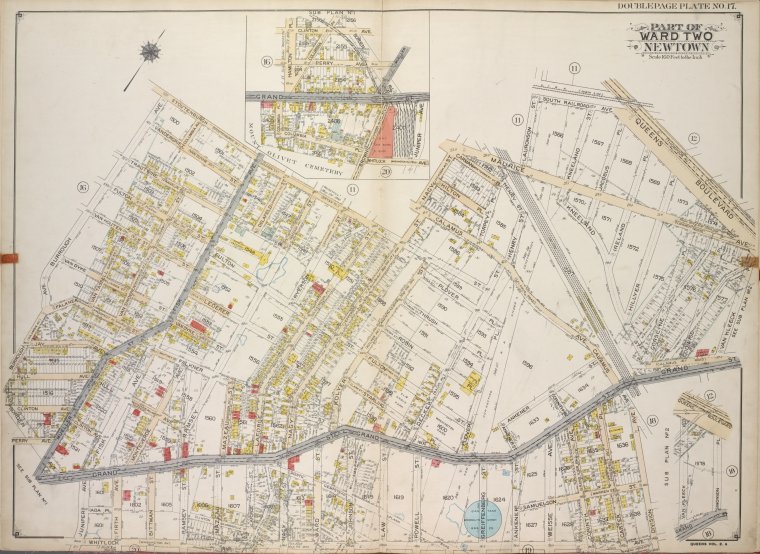
![Queens, Vol. 2A, Double Page Plate No. 17; Part of Ward Two Newtown. [Map bounded by Stoutenburgh St., Nagy St., Maurice Ave., Lauronson St., South Railroad Ave., Queens Blvd.; Including Vankleeck PL., Grand St., Division Ave., Whitlock Ave., Borden Ave., Burrough Ave.]; Sub Plan No. 1; [Map bounded by Clinton Ave., Hamilton PL., Columbia Ave., Perry Ave., Grand St., Muller St., Columbia PL., Brown PL., Juniper Ave., Whitlock Ave.]; Sub Plan No. 2; [Map bounded by Queens Blvd., Van kleeck PL., Simonson PL., Grand St.]](https://images.nypl.org/index.php?id=1801246&t=b)
Lionel Pincus and Princess Firyal Map Division, The New York Public Library. "Queens, Vol. 2A, Double Page Plate No. 17; Part of Ward Two Newtown. [Map bounded by Stoutenburgh St., Nagy St., Maurice Ave., Lauronson St., South Railroad Ave., Queens Blvd.; Including Vankleeck PL., Grand St., Division Ave., Whitlock Ave., Borden Ave., Burrough Ave.]; Sub Plan No. 1; [Map bounded by Clinton Ave., Hamilton PL., Columbia Ave., Perry Ave., Grand St., Muller St., Columbia PL., Brown PL., Juniper Ave., Whitlock Ave.]; Sub Plan No. 2; [Map bounded by Queens Blvd., Van kleeck PL., Simonson PL., Grand St.]" The New York Public Library Digital Collections. 1915. https://digitalcollections.nypl.org/items/7672bf92-fbcf-d2a0-e040-e00a18065300
Lionel Pincus and Princess Firyal Map Division, The New York Public Library. "Queens, Vol. 2A, Double Page Plate No. 17; Part of Ward Two Newtown. [Map bounded by Stoutenburgh St., Nagy St., Maurice Ave., Lauronson St., South Railroad Ave., Queens Blvd.; Including Vankleeck PL., Grand St., Division Ave., Whitlock Ave., Borden Ave., Burrough Ave.]; Sub Plan No. 1; [Map bounded by Clinton Ave., Hamilton PL., Columbia Ave., Perry Ave., Grand St., Muller St., Columbia PL., Brown PL., Juniper Ave., Whitlock Ave.]; Sub Plan No. 2; [Map bounded by Queens Blvd., Van kleeck PL., Simonson PL., Grand St.]" New York Public Library Digital Collections. Accessed March 14, 2025. https://digitalcollections.nypl.org/items/7672bf92-fbcf-d2a0-e040-e00a18065300
Lionel Pincus and Princess Firyal Map Division, The New York Public Library. (1915). Queens, Vol. 2A, Double Page Plate No. 17; Part of Ward Two Newtown. [Map bounded by Stoutenburgh St., Nagy St., Maurice Ave., Lauronson St., South Railroad Ave., Queens Blvd.; Including Vankleeck PL., Grand St., Division Ave., Whitlock Ave., Borden Ave., Burrough Ave.]; Sub Plan No. 1; [Map bounded by Clinton Ave., Hamilton PL., Columbia Ave., Perry Ave., Grand St., Muller St., Columbia PL., Brown PL., Juniper Ave., Whitlock Ave.]; Sub Plan No. 2; [Map bounded by Queens Blvd., Van kleeck PL., Simonson PL., Grand St.] Retrieved from https://digitalcollections.nypl.org/items/7672bf92-fbcf-d2a0-e040-e00a18065300
<ref name=NYPL>{{cite web | url=https://digitalcollections.nypl.org/items/7672bf92-fbcf-d2a0-e040-e00a18065300 | title=
(cartographic)
Queens, Vol. 2A, Double Page Plate No. 17; Part of Ward Two Newtown. [Map bounded by Stoutenburgh St., Nagy St., Maurice Ave., Lauronson St., South Railroad Ave., Queens Blvd.; Including Vankleeck PL., Grand St., Division Ave., Whitlock Ave., Borden Ave., Burrough Ave.]; Sub Plan No. 1; [Map bounded by Clinton Ave., Hamilton PL., Columbia Ave., Perry Ave., Grand St., Muller St., Columbia PL., Brown PL., Juniper Ave., Whitlock Ave.]; Sub Plan No. 2; [Map bounded by Queens Blvd., Van kleeck PL., Simonson PL., Grand St.], (1915)
|author=Digital Collections, The New York Public Library |accessdate=March 14, 2025 |publisher=The New York Public Library, Astor, Lenox, and Tilden Foundations}}</ref>
![Queens, Vol. 2A, Double Page Plate No. 17; Part of Ward Two Newtown. [Map bounded by Stoutenburgh St., Nagy St., Maurice Ave., Lauronson St., South Railroad Ave., Queens Blvd.; Including Vankleeck PL., Grand St., Division Ave., Whitlock Ave., Borden Ave., Burrough Ave.]; Sub Plan No. 1; [Map bounded by Clinton Ave., Hamilton PL., Columbia Ave., Perry Ave., Grand St., Muller St., Columbia PL., Brown PL., Juniper Ave., Whitlock Ave.]; Sub Plan No. 2; [Map bounded by Queens Blvd., Van kleeck PL., Simonson PL., Grand St.]](https://images.nypl.org/index.php?id=1801246&t=t)