


![Bronx, V. A, Plate No. 1 [Map bounded by Fordham Ave., Bear Swamp Rd., Bronx River]](https://images.nypl.org/index.php?id=2003516&t=b)
![Bronx, V. A, Plate No. 2 [Map bounded by Bear Swamp Rd., Fordham Ave.]](https://images.nypl.org/index.php?id=2003517&t=b)
![Bronx, V. A, Plate No. 3 [Map bounded by Bear Swamp Rd., Bronx Park]](https://images.nypl.org/index.php?id=2003518&t=b)
![Bronx, V. A, Plate No. 4 [Map bounded by Morris Park Ave., Bronxdale & Unionport Rd.]](https://images.nypl.org/index.php?id=2003519&t=b)
![Bronx, V. A, Plate No. 5 [Map bounded by Fordham Ave., Williamsbridge Rd., Bear Swamp Rd.]](https://images.nypl.org/index.php?id=2003520&t=b)
![Bronx, V. A, Plate No. 6 [Map bounded by Williamsbridge Rd., Bear Swamp Rd.]](https://images.nypl.org/index.php?id=2003521&t=b)
![Bronx, V. A, Plate No. 7 [Map bounded by Morris Park Ave., West Farms Rd., Unionport Rd.]](https://images.nypl.org/index.php?id=2003522&t=b)
![Bronx, V. A, Plate No. 8 [Map bounded by Morris Park Ave., Bear Swamp Rd., W. Farms Rd., Madison St.]](https://images.nypl.org/index.php?id=2003523&t=b)
![Bronx, V. A, Plate No. 9 [Map bounded by Morris Park Ave., W. Farms Rd.]](https://images.nypl.org/index.php?id=2003524&t=b)
![Bronx, V. A, Plate No. 10 [Map bounded by Morris Park Ave., Unionport Rd., W. Farms Rd., Hancock St.]](https://images.nypl.org/index.php?id=2003525&t=b)
![Bronx, V. A, Plate No. 11 [Map bounded by Morris Park Ave., Bronx Park]](https://images.nypl.org/index.php?id=2003526&t=b)
![Bronx, V. A, Plate No. 12 [Map bounded by Watson's Lane, Bronx River, W. Farms Rd.]](https://images.nypl.org/index.php?id=2003527&t=b)
![Staten Island, Plate No. 2 [Map bounded by Bank, westervelt Ave., York Ave.]](https://images.nypl.org/index.php?id=1957079&t=b)
![Staten Island, Plate No. 3 [Map bounded by Henry, 5th St., Jersey, Hill, york Ave.]](https://images.nypl.org/index.php?id=1957080&t=b)
![Staten Island, Plate No. 4 [Map bounded by Montgomery Ave., Richmond Turn Pike, Sherman]](https://images.nypl.org/index.php?id=1957081&t=b)
![Staten Island, Plate No. 5 [Map bounded by Central Ave., Richmond Turnpike, Montgomery Ave.]](https://images.nypl.org/index.php?id=1957082&t=b)
![Staten Island, Plate No. 6 [Map bounded by New York Bay, Arrietta]](https://images.nypl.org/index.php?id=1957083&t=b)
![Staten Island, Plate No. 7 [Map bounded by Richmond Turn Pike, Arietta, New York bay, Swan, St. Paul's Ave.]](https://images.nypl.org/index.php?id=1957084&t=b)
![Staten Island, Plate No. 8 [Map bounded by Swan, Bay, Clinton, St. Paul's Ave.]](https://images.nypl.org/index.php?id=1957085&t=b)
![Staten Island, Plate No. 9 [Map bounded by Clinton, Bay, Jackson]](https://images.nypl.org/index.php?id=1957086&t=b)
![Staten Island, Plate No. 10 [Map bounded by Jackson, Prospect, Bay, Union Pl., Canal, Boyd, Smith Terrace]](https://images.nypl.org/index.php?id=1957087&t=b)
![Staten Island, Plate No. 11 [Map bounded by Brooks, Vanderbilt, New York Bay, Thompson]](https://images.nypl.org/index.php?id=1957088&t=b)
![Staten Island, Plate No. 12 [Map bounded by Boyd, Brooks, Mc Keon, Varian Cedar]](https://images.nypl.org/index.php?id=1957089&t=b)
![Staten Island, Plate No. 13 [Map bounded by Targee, Elm, Varian, Cedar, Mc Keon]](https://images.nypl.org/index.php?id=1957090&t=b)
![Staten Island, Plate No. 14 [Map bounded by Richmond Rd., Broad, Targee, Young, Forrest St., Maple Ave.]](https://images.nypl.org/index.php?id=1957091&t=b)
![Staten Island, V. 1, Plate No. 1 [Map bounded by Kill van Kull, Westervelt Ave., York Ave.]](https://images.nypl.org/index.php?id=1957327&t=b)
![Staten Island, V. 1, Plate No. 2 [Map bounded by Westervelt Ave., Crescent Ave., Carlyle, York Ave.]](https://images.nypl.org/index.php?id=1957328&t=b)
![Staten Island, V. 1, Plate No. 3 [Map bounded by Richmond Ter., Stuyvesant Pl., Wall, Westervelt Ave.]](https://images.nypl.org/index.php?id=1957329&t=b)
![Staten Island, V. 1, Plate No. 4 [Map bounded by Upper New York Bay, Richmond Ter.]](https://images.nypl.org/index.php?id=1957330&t=b)
![Staten Island, V. 1, Plate No. 5 [Map bounded by Wall, St. Mark's Pl., Montgomery Ave., Benziger Ave., Sherman Ave.]](https://images.nypl.org/index.php?id=1957331&t=b)
![Staten Island, V. 1, Plate No. 6 [Map bounded by Wall, Richmond Ter., Bay, Montgomery Ave.]](https://images.nypl.org/index.php?id=1957332&t=b)
![Staten Island, V. 1, Plate No. 7 [Map bounded by Benziger Ave., Montgomery Ave., Richmond Turnpike, Sherman Ave.]](https://images.nypl.org/index.php?id=1957333&t=b)
![Staten Island, V. 1, Plate No. 8 [Map bounded by Bay, Richmond Turnpike, Montgomery Ave.]](https://images.nypl.org/index.php?id=1957334&t=b)
![Staten Island, V. 1, Plate No. 9 [Map bounded by Richmond Turnpike, Bay, Hannah, Swan, Pavilion Hill Terrace]](https://images.nypl.org/index.php?id=1957335&t=b)
![Staten Island, V. 1, Plate No. 10 [Map bounded by Hannah, Bay, Grant, St. Paul's Ave.]](https://images.nypl.org/index.php?id=1957336&t=b)
![Staten Island, V. 1, Plate No. 11 (1923) [Map bounded by Crescent Ave., Sherman Ave., Brook, Jersey]](https://images.nypl.org/index.php?id=1957337&t=b)
![Staten Island, V. 1, Plate No. 11 (1917) [Map bounded by Crescent Ave., Sherman Ave., Brook, Jersey]](https://images.nypl.org/index.php?id=1957338&t=b)
- The Library Shop
- Privacy Policy
- Rules and Regulations
- Using the Internet
- Website Terms and Conditions
- Gifts of Materials to NYPL
-
© The New York Public Library, 2025
The New York Public Library is a 501(c)(3) | EIN 13-1887440
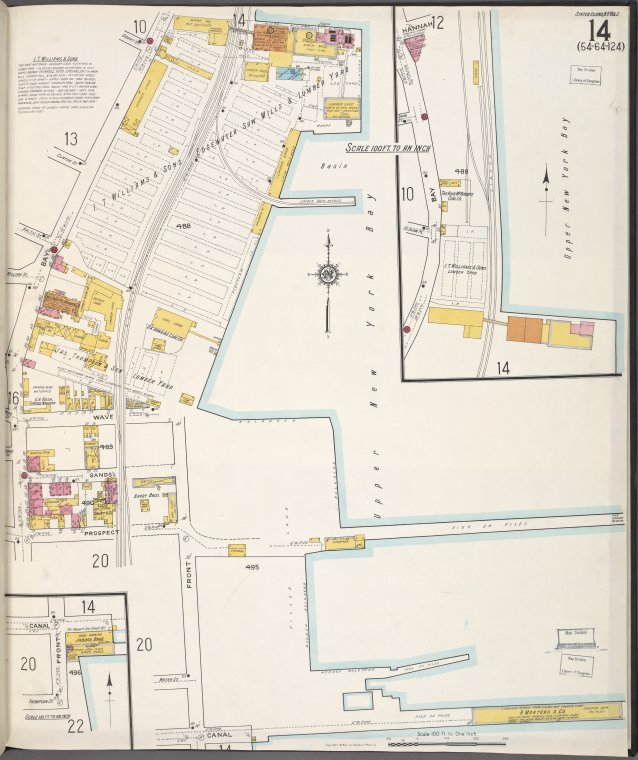
![Staten Island, V. 1, Plate No. 14 (1917) [Map bounded by Bay, Upper New York Bay, Canal]](https://images.nypl.org/index.php?id=1957341&t=b)
Lionel Pincus and Princess Firyal Map Division, The New York Public Library. "Staten Island, V. 1, Plate No. 14 (1917) [Map bounded by Bay, Upper New York Bay, Canal]" The New York Public Library Digital Collections. 1884 - 1936. https://digitalcollections.nypl.org/items/916a9577-a2e0-ff35-e040-e00a18060755
Lionel Pincus and Princess Firyal Map Division, The New York Public Library. "Staten Island, V. 1, Plate No. 14 (1917) [Map bounded by Bay, Upper New York Bay, Canal]" New York Public Library Digital Collections. Accessed February 11, 2025. https://digitalcollections.nypl.org/items/916a9577-a2e0-ff35-e040-e00a18060755
Lionel Pincus and Princess Firyal Map Division, The New York Public Library. (1884 - 1936). Staten Island, V. 1, Plate No. 14 (1917) [Map bounded by Bay, Upper New York Bay, Canal] Retrieved from https://digitalcollections.nypl.org/items/916a9577-a2e0-ff35-e040-e00a18060755
<ref name=NYPL>{{cite web | url=https://digitalcollections.nypl.org/items/916a9577-a2e0-ff35-e040-e00a18060755 | title=
(cartographic)
Staten Island, V. 1, Plate No. 14 (1917) [Map bounded by Bay, Upper New York Bay, Canal], (1884 - 1936)
|author=Digital Collections, The New York Public Library |accessdate=February 11, 2025 |publisher=The New York Public Library, Astor, Lenox, and Tilden Foundations}}</ref>
![Staten Island, V. 1, Plate No. 14 (1917) [Map bounded by Bay, Upper New York Bay, Canal]](https://images.nypl.org/index.php?id=1957341&t=t)