Click to visit the main New York Public Library Homepage
The New York Public Library
Digital Collections
About Digital Collections
Browse
Search only public domain materials
Items
Collections
Divisions
Home
Search
Browse
About
Search only public domain materials
Items
Collections
Divisions
Digital Collections
Using Images
Using Data
Search
Filtered search
Show filters
Hide filters
Show Only Public Domain
topic
Atlases, British
1
Coasts
1
Geography, Ancient
1
Maps in education
1
Nautical charts
1
name
Burghers, M
3
L'Isle, Guillaume de, 1675-1726
3
Stemmers, I
3
University of Oxford
3
Wells, Edward, 1667-1727
3
More
Less
collection
Lawrence H. Slaughter Collection of English maps, charts, globes, books and atlases
4
Maps of North America
3
Atlases, gazetteers, guidebooks and other books
2
place
x
Caribbean Area
North America
5
Mexico
3
Maps
2
Atlantic Coast (North America)
1
More
Less
genre
Maps
9
Nautical charts
2
publisher
Chez Iean Covens & Corneille Mortier
2
Chez Jean Covens & Corneille Mortier
1
Johanne van Keulen
1
Printed at the Theater,
1
Printed by T.W. for R. Bonwicke, J. Walthoe, R. Wilkin, and T. Ward?,
1
More
Less
division
Map Division
9
type
cartographic
9
Date Range
to
9 results found
Filtering on:
x
Date
: 1686 - 1725
x
Place
: Caribbean Area
Sort by:
Title
Date created
Date digitized
Sequence
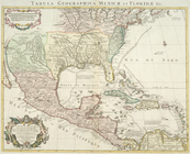
Carte du Mexique et de la Flo…
Pas kaart van West Indien : b…
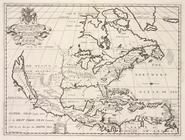
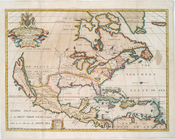
A new map of North America sh…
A new map of North America sh…
A new map of North America sh…
Carte du Mexique et de la Flo…
Carte du Mexique et de la Flo…
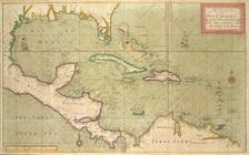
A new and correct large draug…
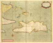
A chart of the Iland of HISPA…