Click to visit the main New York Public Library Homepage
The New York Public Library
Digital Collections
About Digital Collections
Browse
Search only public domain materials
Items
Collections
Divisions
Home
Search
Browse
About
Search only public domain materials
Items
Collections
Divisions
Digital Collections
Using Images
Using Data
Search
Filtered search
Show filters
Hide filters
Show Only Public Domain
topic
History
61
Fishes
29
Forts & fortifications
28
Homes and haunts
18
Nautical charts
17
More
Less
name
Palmer, J. A
35
Nowell, F. A
33
Holbrook, John Edwards, 1794-1871
29
T. Sinclair's Lith
28
Barnard, George N., 1819-1902
27
More
Less
collection
Robert N. Dennis collection of stereoscopic views
236
Maps of North America
67
Wallach Division Picture Collection
42
Ichthyology of South Carolina. Vol. I
29
"The Pageant of America" Collection
12
More
Less
place
x
South Carolina
Charleston (S.C.)
154
Charleston
73
United States
63
Southern States
29
More
Less
genre
Photographs
251
Stereographs
236
Maps
75
Prints
69
Scientific illustrations
28
More
Less
publisher
Russell and Jones
29
G. N. Barnard
27
J. A. Palmer
24
F. A. Nowell
22
O. Pierre Havens
15
More
Less
division
Wallach Division: Photography Collection
248
Map Division
75
Wallach Division: Picture Collection
42
General Research Division
29
Wallach Division: Print Collection
18
More
Less
type
still image
348
cartographic
75
text
13
Date Range
to
431 results found
Filtering on:
x
Date
: 1705 - 1864
x
Place
: South Carolina
Sort by:
Title
Date created
Date digitized
Sequence
Bill of sale for mulatto man …
Five generations on Smith's P…
Document
m
Statement on self-defense of …
Establishing the Colony of Ge…
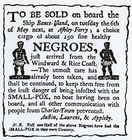
To be sold, on board the ship…
To accompany Willard's histor…
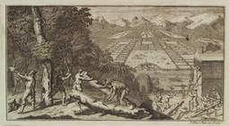
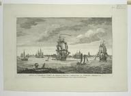
A view of Charles Town, the c…
Freed slave escorting her chi…
Black Mother being separated …
A black family being separated
A black woman pleading for th…
m
Preliminary chart of Port Roy…
J.H. Colton's topographical m…
Map of comparison of Maffitt'…
Preliminary chart of North Ed…
m
Charleston District, South Ca…
The harbour of Charles Town i…
m
A sketch of the operations be…
A sketch of the environs of C…
m
The city of Charleston, South…
Plan of the siege of Charlest…
Plan of the siege of Charlest…
A draught of Port Royal Harbo…
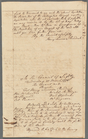
Council of Safety minutes, [P…
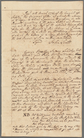
Council of Safety minutes, [P…
Middle Georgia & South Caroli…
Preliminary chart of Port Roy…
New map of Charleston Harbor:…
Fortifications of Charleston …
Tybee Bay and Calibogue Sound…
The state of South Carolina :…
An accurate map of North and …
Sketch of Beaufort, Port Roya…
Military map of South Carolina
Preliminary chart of Bull's B…
Preliminary survey of Winyah …
Charleston : a map showing th…
Preliminary chart of North Ed…
Map of the Sea-Coast of South…
Plan of the siege of Charlest…
A new and accurate map of the…
A New and accurate map of the…
A new and accurate map of the…
Preliminary chart of Port Roy…
St. Helena Sound, South Carol…
Preliminary chart of Calibogu…
South-Carolina and parts adja…
Preliminary chart of the sea …
Sketch of portions of seacoas…
1
2
Previous
Next
1
2
Previous
Next