Click to visit the main New York Public Library Homepage
The New York Public Library
Digital Collections
About Digital Collections
Browse
Search only public domain materials
Items
Collections
Divisions
Home
Search
Browse
About
Search only public domain materials
Items
Collections
Divisions
Digital Collections
Using Images
Using Data
Search
Filtered search
Show filters
Hide filters
Show Only Public Domain
topic
Blacks
1
British
1
Forts & fortifications
1
Missions
1
Ships
1
name
Bowles, Carington, 1724-1793
1
Bradford, William
1
Burgis, William, active 1722-1736
1
Canot, Pierre Charles, 1710-1777
1
Carwitham, J. (John)
1
More
Less
collection
I. N. Phelps Stokes Collection of American Historical Prints
2
A plan of the city of New York from an actual survey
1
Lawrence H. Slaughter Collection of English maps, charts, globes, books and atlases
1
The Eno collection of New York City views
1
place
x
New York (N.Y.)
New England
2
Atlantic Coast (U.S.)
1
Middle Atlantic States
1
Middle Atlantic States -- Maps -- Early works to 1800
1
More
Less
genre
Prints
4
Maps
3
Plans
1
publisher
Carington Bowles
1
Printed by Joseph Downing
1
Printed by Joseph Downing,
1
William Bradford
1
division
Wallach Division: Print Collection
3
Map Division
1
Rare Book Division
1
type
cartographic
3
still image
2
Date Range
to
5 results found
Filtering on:
x
Date
: 1730 - 1731
x
Place
: New York (N.Y.)
Sort by:
Title
Date created
Date digitized
Sequence
A plan of the city of New Yor…
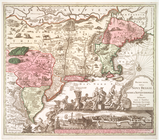
A map of New England, New Yor…
Recens edita totius Novi Belg…
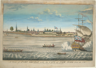
A view of Fort George with th…
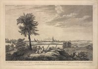
A south east view of the City…