Click to visit the main New York Public Library Homepage
The New York Public Library
Digital Collections
About Digital Collections
Browse
Search only public domain materials
Items
Collections
Divisions
Home
Search
Browse
About
Search only public domain materials
Items
Collections
Divisions
Digital Collections
Using Images
Using Data
Search
Filtered search
Show filters
Hide filters
Show Only Public Domain
topic
Nautical charts
2
name
Sayer, Robert, 1725-1794
3
Fry, Joshua, approximately 1700-1754
2
Hinton, John, -1781
2
Jefferson, Peter, 1708-1757
2
Berndt, Johann Christian, 1748-1812
1
More
Less
collection
Maps of North America
5
Lawrence H. Slaughter Collection of English maps, charts, globes, books and atlases
3
The Eno collection of New York City views
1
place
x
Maps
Early works to 1800
8
America
3
Colonies
3
Great Britain
3
More
Less
genre
Maps
8
Prints
1
publisher
J. Hinton
1
J. Hinton?
1
Printed for Robert Sayer, No. 53 Fleet Street as the Act Directs,
1
Printed for Robt. Sayer & Jno. Bennett, map & sea chart sellers, No. 53 Fleet Street
1
Printed for Robt. Sayer, at No. 53 in Fleet Street
1
More
Less
division
Map Division
8
Wallach Division: Print Collection
1
type
cartographic
8
still image
1
Date Range
to
9 results found
Filtering on:
x
Date
: 1775 - 1776
x
Place
: Maps
Sort by:
Title
Date created
Date digitized
Sequence
Carte de la Virginie et du Ma…
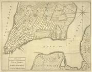
A Plan of the city and enviro…
A chart of the Atlantic Ocean…
A chart of Delaware Bay and R…
An accurate map of North Amer…
Schauplatz des Kriegs zwische…
A map of the most inhabited p…
An Accurate map of the presen…
m
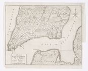
A plan of the city and enviro…