Click to visit the main New York Public Library Homepage
The New York Public Library
Digital Collections
About Digital Collections
Browse
Search only public domain materials
Items
Collections
Divisions
Home
Search
Browse
About
Search only public domain materials
Items
Collections
Divisions
Digital Collections
Using Images
Using Data
Search
Filtered search
Show filters
Hide filters
Show Only Public Domain
collection
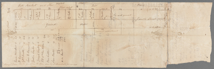
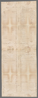
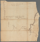
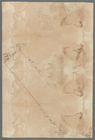
Bancker plans
156
genre
x
Surveys
Maps
142
land surveys
126
Documents
33
division
Manuscripts and Archives Division
156
type
cartographic
142
text
33
Date Range
to
156 results found
Filtering on:
x
Date
: 1800 - 1803
x
Genre
: Surveys
Sort by:
Title
Date created
Date digitized
Sequence
m
Nicholas Carmer and Mary Clar…
m
1800 October 29
m
Peter Schermerhorn's three lo…
m
Barclay, Robinson, Greenwich …
m
Bowery Lane
m
Eight acres at Bloomingdale
m
1801 December 21
m
John Hopper's at Bloomingdale
m
John Wilkes's five acre lot a…
m
Homestead at Bloomingdale
m
Bloomingdale
m
Bloomingdale
m
Webber and Van Arden
m
Augustus, Barley and George S…
m
Anne Street
m
John Thurman's lots - Wall St…
m
Pump, Eagle, Second, Third, F…
m
Pine Street from Pearl Street…
m
Map of Kip's Bay
m
Kip's Bay
m
Harlem Creek
m
James Roosevelt at Harlem
m
Hellgate Road
m
Hammond and Greenwich Street
m
Thomas B. Clark's ground at G…
m
1800 October 29
m
Now Ireland's, formerly schoo…
m
James Seton's and Cruger's in…
m
Greenwich Street
m
Anthony Rutgers's land and Ch…
m
Fly Market
m
Cherry from George to Rutgers
m
From Paulus Hook to Passaic R…
m
Staten Isle
m
Copy of a map of land at West…
m
Forty three acres of land at …
m
Bartow at Westchester
m
From Marketfield to Courtland…
m
Charter officers draft
m
Water lots back of A. V. Cotl…
m
Mrs. Delancey's dowry
m
Lots on Cherry Street and Wat…
m
Baskenridge
m
Arthur's Meadow
m
1803 April 6
m
Long Island Sound
m
Near Peck Slip - water lots
m
Bushwich and Newtown - Turnpi…
m
Susquehanna
m
Hospital