Click to visit the main New York Public Library Homepage
The New York Public Library
Digital Collections
About Digital Collections
Browse
Search only public domain materials
Items
Collections
Divisions
Home
Search
Browse
About
Search only public domain materials
Items
Collections
Divisions
Digital Collections
Using Images
Using Data
Search
Filtered search
Show filters
Hide filters
Show Only Public Domain
topic
x
Navigation
Nautical charts
9
Harbors
3
Inlets
2
Coins, Roman
1
More
Less
name
Bache, A. D. (Alexander Dallas), 1806-1867
7
United States Coast Survey
7
Almy, John Jay, 1815-1895
3
Stevens, Isaac Ingalls, 1818-1862
3
Maffitt, John Newland, 1819-1886
2
More
Less
collection
Maps of North America
9
Wonders: Images of the Ancient World
2
Lawrence H. Slaughter Collection of English maps, charts, globes, books and atlases
1
place
Mexico, Gulf of
3
Virginia
3
Atlantic Coast
2
Atlantic Coast (Va.)
2
Atlantic Ocean
2
More
Less
genre
Maps
10
Nautical charts
9
Bathymetric maps
6
Prints
1
Reconstructions
1
publisher
U.S. Coast Survey
4
Coast Survey Office
1
Government Printing Office
1
Harper
1
Printed ... by Edmund M. Blunt (Proprietor) for Cushing & Appleton, Salem : Sold by every book-seller, ship-chandler, and mathematical-instrument-maker in the United States and West-Indies,
1
More
Less
division
Map Division
10
Wallach Division: Picture Collection
2
type
cartographic
10
still image
2
Date Range
to
12 results found
Filtering on:
x
Date
: 1801 - 1853
x
Topic
: Navigation
Sort by:
Title
Date created
Date digitized
Sequence
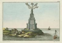
Pharos at Alexandria
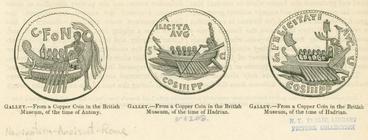
Roman galleys during the time…
Preliminary sketch of Cherrys…
Harbor of Michigan City, Indi…
Preliminary sketch of Mobile …
Preliminary sketch of Chincot…
Preliminary sketch of Wachapr…
Sketch of Frying-Pan Shoals a…
Savannah River, reconnaissanc…
Preliminary chart of Key-West…
m
An accurate chart of the coas…
Chart of the Atlantic Ocean.
End of results
|
Top