Click to visit the main New York Public Library Homepage
The New York Public Library
Digital Collections
About Digital Collections
Browse
Search only public domain materials
Items
Collections
Divisions
Home
Search
Browse
About
Search only public domain materials
Items
Collections
Divisions
Digital Collections
Using Images
Using Data
Search
Filtered search
Show filters
Hide filters
Show Only Public Domain
topic
Administrative and political divisions
6
Indians of North America
4
Antislavery movements
2
Geology
2
Real property
2
More
Less
name
Farmer, John, 1798-1859
3
Burr, David H., 1803-1875
2
Owen, David Dale, 1807-1860
2
Rawdon, Clark & Co
2
United States. Government Printing Office
2
More
Less
collection
Maps of North America
14
Slavery resolutions
2
Wallach Division Picture Collection
1
place
x
Wisconsin
Michigan
7
Illinois
5
United States
3
Great Lakes Region (North America)
2
More
Less
genre
Maps
14
Cadastral maps
2
Documents
2
Geological cross-sections
2
Geological maps
2
More
Less
publisher
Government Printing Office
2
John Farmer
2
s.n
2
publisher not identified
2
David H. Burr
1
More
Less
division
Map Division
14
Schomburg Manuscripts, Archives and Rare Books Division
2
Wallach Division: Picture Collection
1
type
cartographic
14
still image
3
Date Range
to
17 results found
Filtering on:
x
Date
: 1814 - 1848
x
Place
: Wisconsin
Sort by:
Title
Date created
Date digitized
Sequence
Map of the territories of Mic…
m
Map of Michigan & part of Wis…
An improved map of the survey…
Improved map of the territori…
Sketch of the public surveys …
Traveller's map of Michigan, …
General map to accompany the …
A new sectional map of the st…
Geological chart of part of I…
Geological section from the m…
Plat of the private claims at…
Whitesboro, Brown Co., W.T.
A new map of Illinois and par…
Map of Illinois with parts of…
Victory over Black Hawk
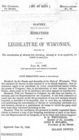
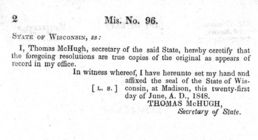
Resolutions of the legislatur…
Resolutions of the legislatur…
End of results
|
Top