Click to visit the main New York Public Library Homepage
The New York Public Library
Digital Collections
About Digital Collections
Browse
Search only public domain materials
Items
Collections
Divisions
Home
Search
Browse
About
Search only public domain materials
Items
Collections
Divisions
Digital Collections
Using Images
Using Data
Search
Filtered search
Show filters
Hide filters
Show Only Public Domain
topic
Real property
38
Administrative and political divisions
27
Landowners
27
Nautical charts
19
Railroads
16
More
Less
name
Bache, A. D. (Alexander Dallas), 1806-1867
21
United States Coast Survey
21
Pease, Richard H., 1813-1869
18
Atwood, John M., approximately 1818-
13
Battelle, W
11
More
Less
collection
Maps of North America
134
Maps of New York City and State
91
Robert N. Dennis collection of stereoscopic views
18
Atlases, gazetteers, guidebooks and other books
2
Maps of Central America
2
More
Less
place
New York (State)
63
New York (N.Y.)
31
Massachusetts
29
United States
25
New York
20
More
Less
genre
Maps
234
Cadastral maps
21
Photographs
18
Stereographs
18
Nautical charts
16
More
Less
publisher
publisher not identified
40
U.S. Coast Survey
10
s.n
7
U.S. Coast Survey Office
5
Lith. of R.H. Pease
4
More
Less
division
x
Map Division
Wallach Division: Photography Collection
18
type
cartographic
232
still image
23
Date Range
to
252 results found
Filtering on:
x
Date
: 1849 - 1851
x
Division
: Map Division
Sort by:
Title
Date created
Date digitized
Sequence
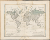
Ethnographic map of the world…
m
Map of the city of Brooklyn, …
Plan of the town of Brooklyn …
City guide
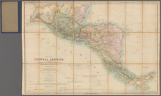
A new map of Central America …
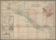
Map of Central America includ…
Map of the Great Salt Lake an…
Phelps's national map of the …
Map of the frontiers of the n…
Map of the territory of Minne…
Geological map of the distric…
Sketch of the public surveys …
To the citizens of Philadelph…
Map of the mouth of St. Clair…
Diagram of the state of Misso…
Geological map of Keweenaw Po…
Geological map of Isle Royale…
Section and diagram illustrat…
Diagram of the state of Michi…
Map of the northern peninsula…
Map of the city of Saint Paul…
Geological map of the distric…
Geological map of Isle Royale…
Barometric profile of the rou…
Map of the tertiary of Essex …
Geological map of the Lake Su…
Map of Chicago and vicinity
A sketch of the public survey…
A new map of the state of Ohio
Plan of a mineral estate situ…
m
This plan of the city of Balt…
Geological reconnaissances in…
Alexander von Humboldt's Syst…
A correct map of the Bay of S…
Reconnaissance of Trinidad Ba…
Sketch of the route of Capt. …
Map of the territory of New M…
Mare Island Straits, Californ…
Map of the city of San Franci…
Official map of the city of S…
Topographical sketch of the s…
The Sacramento Valley from th…
Plan of Ohio City in the stat…
Geological and sectional map …
Map of the states of Missouri…
Map of lands belonging to Jam…
Map of the "Hunter Fly Farm" …
A map of Maryland and Virgini…
Map of Indiana
Indiana, 1820
1
2
Previous
Next
1
2
Previous
Next