Click to visit the main New York Public Library Homepage
The New York Public Library
Digital Collections
About Digital Collections
Browse
Search only public domain materials
Items
Collections
Divisions
Home
Search
Browse
About
Search only public domain materials
Items
Collections
Divisions
Digital Collections
Using Images
Using Data
Search
Filtered search
Show filters
Hide filters
Show Only Public Domain
topic
x
Railroads
Administrative and political divisions
51
Trestles
30
Canals
17
Ferries
15
More
Less
name
Portland & Ogdensburg Railroad Company
42
G. H. Aldrich & Co
27
Kilburn Brothers
17
G.W. & C.B. Colton & Co
15
Colton, G. Woolworth (George Woolworth), 1827-1901
6
More
Less
collection
Maps of North America
82
Robert N. Dennis collection of stereoscopic views
76
Maps of New York City and State
63
Wallach Division Picture Collection
10
Publisher's proofs of the publications of L. Prang & Co., and scrapbooks of colored advertising cards, published by L. Prang & Co. and other firms
4
More
Less
place
New York (State)
71
New Hampshire
55
White Mountains (N.H. and Me.)
49
Crawford Notch (N.H.)
47
New York
31
More
Less
genre
Maps
145
Photographs
80
Stereographs
76
Prints
12
Cadastral maps
8
More
Less
publisher
G.W. & C.B. Colton & Co
12
publisher not identified
8
Asher & Adams
4
Gaylord Watson
4
M. Dripps
4
More
Less
division
Map Division
145
Wallach Division: Photography Collection
78
Wallach Division: Print Collection
7
Wallach Division: Picture Collection
5
Milstein Division
2
type
cartographic
145
still image
98
text
3
Date Range
to
242 results found
Filtering on:
x
Date
: 1866 - 1876
x
Topic
: Railroads
Sort by:
Title
Date created
Date digitized
Sequence
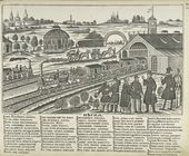
Pesnia. 'Bliz Krasnykh Vorot …
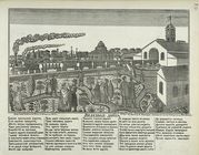
Zheleznaia doroga.
Map of the country thirty thr…
Map showing location of lands…
Map of the country thirty thr…
Map of the country thirty thr…
Map of New York and vicinity …
Map of the country thirty thr…
m
Map of the city of Brooklyn
m
Map of the City of New York a…
m
Watson's new map of New York,…
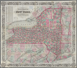
Map of the state of New York:…
Map of the rail roads of the …
Map of the rail roads of the …
Map shewing the location of t…
Topographical map of that por…
Map showing the New York and …
McClung's map of Minnesota : …
m
Revised map of the state of T…
m
Colton's new sectional map of…
Railroad map of Michigan
Rice's township & rail road m…
Indian Territory
Blanchard's map of Wisconsin …
Map of the state of Texas [an…
New map of Missouri
Map showing the main line and…
Johnson's Vermont and New Ham…
Railway map of Philadelphia :…
Blanchard's Guide map of Kans…
Congressional map of the stat…
Portion of the copper distric…
Colton's Guide map of Michigan
Map showing the route of the …
Thayer's map of Colorado
A new map of the states of Ca…
Map of California : to accomp…
The North End Mines : field …
m
Colton's new map of Long Isla…
Map of the town of Eastcheste…
Colton's railroad & township …
Map showing the anthracite co…
Map of the mines, canals, and…
m
City of Houston, Harris Co., …
County map of the state of Ca…
Railroad map of the City of S…
Railroad map of the City of S…
m
A new map of Indiana : exhibi…
Map showing the economic mine…
Fragment of a map, covering p…