Click to visit the main New York Public Library Homepage
The New York Public Library
Digital Collections
About Digital Collections
Browse
Search only public domain materials
Items
Collections
Divisions
Home
Search
Browse
About
Search only public domain materials
Items
Collections
Divisions
Digital Collections
Using Images
Using Data
Search
Filtered search
Show filters
Hide filters
Show Only Public Domain
topic
x
Administrative and political divisions
Railroads
23
Landowners
10
Election districts
7
Canals
6
More
Less
name
Blanchard, Rufus, 1821-1904
5
G.W. & C.B. Colton & Co
5
Walling, Henry Francis, 1825-1888
5
Sampson, Davenport & Co
4
Watson, Gaylord
4
More
Less
collection
Maps of North America
45
Maps of New York City and State
43
place
New York (State)
36
New York (N.Y.)
12
Manhattan (New York, N.Y.)
11
Massachusetts
11
Brooklyn (New York, N.Y.)
10
More
Less
genre
Maps
88
Cadastral maps
3
Aerial views
1
Nautical charts
1
publisher
publisher not identified
11
Sampson, Davenport & Co
4
J.B. Beers & Co
3
Published by Rufus Blanchard
3
A.J. Johnson
2
More
Less
division
Map Division
88
type
cartographic
88
still image
1
text
1
Date Range
to
88 results found
Filtering on:
x
Date
: 1869 - 1873
x
Topic
: Administrative and political divisions
Sort by:
Title
Date created
Date digitized
Sequence
Map showing location of lands…
Map of the county of Kings, s…
Watson's new map of the city …
Map of the rail roads of the …
McClung's map of Minnesota : …
Map of Chicago and its wester…
m
Colton's new sectional map of…
m
Map of the city of St. Louis,…
Johnson's Minnesota
Rice & Reed's township map of…
Rice's township & rail road m…
Map of the state of Missouri …
New and improved map of the c…
Blanchard's Guide map of Kans…
Johnson's Kansas and Nebraska
Thayer's map of Colorado
Half of an unidentified map s…
m
Map of the city and suburbs o…
Colton's sectional map of the…
Fragment of a map, covering p…
Hampshire and Hampden countie…
Franklin County
Map of the state of Missouri
Map of the city of St. Louis …
Railroad map of Iowa
Map of Chester Co., Pennsylva…
m
Hardee's geographical, histor…
City of Chicago
Map of Indiana
Map of Cook and DuPage Counti…
m
Blanchard's map of Cook and D…
Colton's new topographical ma…
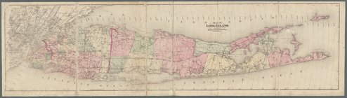
Map of Long Island
County and railroad map of th…
Map of south Florida : showin…
m
Topographical map of Hunterdo…
Northern coast of Long Island…
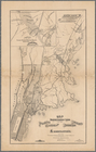
Map showing location of lands…
Johnson's Massachusetts, Conn…
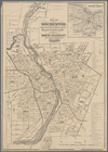
Map of Rochester: from the la…
Map of the city of Worcester:…
Map of the city of Worcester:…
Plan of Boston and its vicini…
Map of Boston: from the lates…
Map of New England with adjac…
North Berwick: [Maine]
Map of Berkshire County, Mass…
Map of Pennsylvania showing p…
Map of southern New Hampshire
Map of Boston: from the lates…