Click to visit the main New York Public Library Homepage
The New York Public Library
Digital Collections
About Digital Collections
Browse
Search only public domain materials
Items
Collections
Divisions
Home
Search
Browse
About
Search only public domain materials
Items
Collections
Divisions
Digital Collections
Using Images
Using Data
Search
Filtered search
Show filters
Hide filters
Show Only Public Domain
topic
x
Landowners
Real property
126
Administrative and political divisions
33
Railroads
8
Roads
7
More
Less
name
Bourquin, F. (Frederick), 1808-
33
Warner & Foote
31
Worley & Bracher
25
Bracher, Wm. (William)
17
Beers, D. G. (Daniel G.)
9
More
Less
collection
Maps of North America
109
Maps of New York City and State
52
Collection of property maps of parts of Westchester County, N.Y. : covering mostly Eastchester, Mount Vernon, and Yonkers
1
The Negro in the New World
1
The old South and the new: a complete illustrated history of the Southern states, their resources, their people and their cities, and the inspiring story of their wonderful growth in industry and riches
1
place
New York (State)
52
Iowa
19
New York
14
Minnesota
12
Kentucky
8
More
Less
genre
Maps
162
Cadastral maps
112
Manuscript maps
7
Illustrations
6
Wall maps
4
More
Less
publisher
Published by Warner & Foote
25
publisher not identified
19
D.G. Beers & Co
6
Warner & Foote
6
Hyde & Company
5
More
Less
division
Map Division
162
Schomburg Jean Blackwell Hutson Research and Reference Division
2
type
cartographic
162
still image
6
text
2
Date Range
to
164 results found
Filtering on:
x
Date
: 1877 - 1914
x
Topic
: Landowners
Sort by:
Title
Date created
Date digitized
Sequence
Lloyd's topographical map of …
m
Map of the Cedar Knolls, at B…
m
Map of the borough of Queens,…
m
New map of Kings and Queens c…
m
Driving road chart of the cou…
Livingston Heights : Livingto…
Map of the Rhode Island state…
A map of the town of New-ark …
m
Map of Bates County, Missouri
m
Map of Johnson County, Missou…
m
Map of Goodhue County, Minnes…
m
Map of Stearns County, Minnes…
m
Map of Hennepin County, Minne…
m
Map of Meeker County, Minneso…
m
Map of McLeod County, Minneso…
m
Map of Christian County, Ky. …
Plan of the Brunswick lots in…
A map of St. Augustine & vici…
m
New map of Kings and Queens c…
Map of a portion of Point Ke…
m
Map of Sibley County, Minneso…
m
Map of Scott County, Minnesot…
m
Map of LeSueur County, Minnes…
m
Map of Ramsey and Washington …
Map of Rochester, Olmsted Co.…
A map of Philadelphia and par…
Map of Lake Minnetonka : show…
m
Abbott's map of the city of M…
Map of a portion of the Salem…
m
Map of Monroe County, Wiscons…
Map of St. Joseph, Mo. and vi…
m
Map of Delaware County, Iowa …
m
Map of Polk County, Iowa : dr…
Map of Leavenworth, Kansas
m
Map of O'Brian County, Iowa :…
m
Map of Wright County, Iowa : …
m
Map of Adams County, Iowa : d…
Map of the city of Topeka, Sh…
Traver's map of Tacoma and en…
Whitney's map of Seattle and …
m
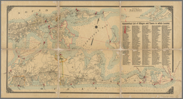
Map of Long Island: based upo…
m
Map of Long Island: based upo…
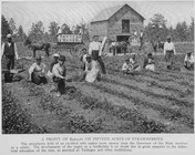
A profit of $2,723.61 on fift…
Birds-eye view of the Blue Gr…
Map of part of the Manor of P…
m
Map of Multnomah County, Oreg…
Map of Baker City, Oregon
Map of revolutionary camp gro…
m
Map of Maury Co., Tennessee :…
m
Map of Haywood County, Tenn. …