Click to visit the main New York Public Library Homepage
The New York Public Library
Digital Collections
About Digital Collections
Browse
Search only public domain materials
Items
Collections
Divisions
Home
Search
Browse
About
Search only public domain materials
Items
Collections
Divisions
Digital Collections
Using Images
Using Data
Search
Filtered search
Show filters
Hide filters
Show Only Public Domain
topic
Real property
463
Historic buildings
60
Streets
42
Buildings
37
Houses
36
More
Less
name
E.B. Hyde & Co
231
Ullitz, Hugo
231
E. Belcher Hyde Map Company
113
G.M. Hopkins & Co
108
E. Robinson Co
77
More
Less
collection
Atlases of New York City
453
Scrapbooks of New York City views
102
Photographic views of New York City, 1870's-1970's, from the collections of the New York Public Library
91
Maps of New York City and State
84
Collection of photographs taken by Daniel B. Austin and his associate, Adam Dove, depicting buildings, street scenes and Brooklyn and Long Island views, particularly Flatbush, Gravesend and New Utrecht, and generally for the period 1885-1914
40
More
Less
place
x
Brooklyn (New York, N.Y.)
New York (State)
671
New York
652
New York (N.Y.)
279
Maps
117
More
Less
genre
Maps
507
Photographs
307
Clippings
35
Drawings
28
Prints
20
More
Less
publisher
E.B. Hyde & Co
118
E. Belcher Hyde
113
G.M. Hopkins & Co
108
E. Robinson Co
77
G. W. Bromley & E. Robinson
37
More
Less
division
Map Division
537
Milstein Division
316
Wallach Division: Picture Collection
26
Wallach Division: Photography Collection
11
Wallach Division: Print Collection
11
More
Less
type
cartographic
512
still image
380
text
32
notated music
2
Date Range
to
916 results found
Filtering on:
x
Date
: 1878 - 1904
x
Place
: Brooklyn (New York, N.Y.)
Sort by:
Title
Date created
Date digitized
Sequence
m
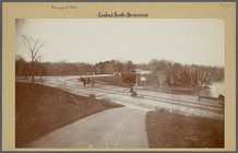
Brooklyn: Prospect Park.
Floral steps, Prospect Park, …
Records of searches in relati…
Map of the borough of Brookly…
Map of lots belonging to the …
m
The Blanchard Press correctly…
King's bird's-eye view of Bro…
Guide map to the Brooklyn and…
Map of the borough of Brookly…
The Brooklyn of the future : …
Map showing proposed extensio…
Map of the borough of Brookly…
Rand, McNally & Co.'s new han…
Rand McNally standard map of …
m
Sea Gate, New York Harbor
m
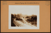
Brooklyn: Empire Boulevard - …
m
Brooklyn: Devoe Street - Lori…
Map of New York, Brooklyn, an…
New map of the great metropol…
m
New guide map of New York Cit…
m
Taunton new guide map and dir…
m
Map of the borough of Brookly…
Plan of Bay Ridge Parkway
Map of the enlarged city of B…
m
New map of Kings and Queens c…
m
Watson's new map of New York …
m
Watson's new map of New York …
m
Brooklyn: Cropsey Avenue - Ba…
m
Brooklyn: Cropsey Avenue - 7t…
m
Brooklyn: Clarendon Road - 22…
m
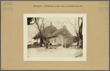
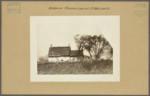
Brooklyn: Canarsie Lane - 58t…
m
Brooklyn: Canarsie Lane - 58t…
m
Brooklyn: Bushwick Avenue - C…
m
Brooklyn: Bushwick Avenue - H…
m
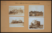
Brooklyn: Brighton Beach Aven…
m
Brooklyn: Brighton Beach Aven…
m
Brooklyn: Bedford Avenue - Ro…
m
Brooklyn: Bedford Avenue - Di…
m
Brooklyn: Bedford Avenue - Di…
m
Brooklyn: Bath Avenue - Bay 1…
m
Brooklyn: Barbey Street - Dum…
m
Brooklyn: Atlantic Avenue - W…
m
Brooklyn: Atlantic Avenue - N…
m
Brooklyn: Clark Street - Fult…
m
Chapel Street in New Haven, C…
m
Brooklyn: 36th Street (East) …
m
Brooklyn: 35th Street (East) …
m
Brooklyn: 35th Street (East) …
m
Brooklyn: 23rd Avenue - Crops…
m
Brooklyn: 23rd Avenue - Crops…
1
2
3
4
Previous
Next
1
2
3
4
Previous
Next