Click to visit the main New York Public Library Homepage
The New York Public Library
Digital Collections
About Digital Collections
Browse
Search only public domain materials
Items
Collections
Divisions
Home
Search
Browse
About
Search only public domain materials
Items
Collections
Divisions
Digital Collections
Using Images
Using Data
Search
Filtered search
Show filters
Hide filters
Show Only Public Domain
topic
Real property
15
Landowners
8
Administrative and political divisions
4
Railroads
2
Cherokee Indians
1
More
Less
name
Bourquin, F. (Frederick), 1808-
2
Langley, Henry G
2
Painter & Co
2
Wilbur, Geo. B
2
Allen, C. R., active 1878-1908
1
More
Less
collection
Maps of North America
12
Maps of New York City and State
6
place
New York (State)
4
California
3
Brooklyn (New York, N.Y.)
2
Illinois
2
Iowa
2
More
Less
genre
x
Cadastral maps
Maps
18
Manuscript maps
2
Wall maps
1
publisher
publisher not identified
4
H.G. Langley
2
C.R. Allen
1
Charles Crooke
1
Cherokee Strip Live Stock Association?
1
More
Less
division
Map Division
18
type
cartographic
18
still image
1
text
1
Date Range
to
18 results found
Filtering on:
x
Date
: 1892 - 1893
x
Genre
: Cadastral maps
Sort by:
Title
Date created
Date digitized
Sequence
Livingston Heights : Livingto…
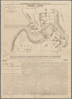
Map of the Cherokee strip, In…
m
Map of Sibley County, Minneso…
Springfield, Ill. 1892
m
The City of Stockton and vici…
Guidemap of the city of San F…
Guidemap of the City of San F…
Map of Omaha and Council Bluf…
m
Map of Elizabeth City Co., Va…
Allen's outline map of Ottumw…
Plat of the city of Tallapoos…
Map of South Waukegan showing…
Webster Park, Franklin, N.H.
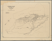
Tuxedo Park, Orange Co., New …
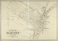
Map of Albany, New York
Map of central portion of the…
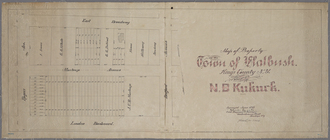
Map of property in the town o…
Map of property belonging to …
End of results
|
Top