Click to visit the main New York Public Library Homepage
The New York Public Library
Digital Collections
About Digital Collections
Browse
Search only public domain materials
Items
Collections
Divisions
Home
Search
Browse
About
Search only public domain materials
Items
Collections
Divisions
Digital Collections
Using Images
Using Data
Search
Filtered search
Show filters
Hide filters
Show Only Public Domain
topic
Building construction
225
Buildings
178
Streets
178
Houses
148
Brownstone buildings
147
More
Less
name
Cathedral of St. John the Divine (New York, N.Y.)
179
Rosenfeld, Morris, 1884-1968
169
Brown Brothers (New York, N.Y.)
165
G.W. Bromley & Co
103
Wurts Bros. (New York, N.Y.)
72
More
Less
collection
Photographic views of New York City, 1870's-1970's, from the collections of the New York Public Library
969
Morris Rosenfeld Photographs
169
Atlases of New York City
103
Maps of New York City and State
53
Robert N. Dennis collection of stereoscopic views
28
More
Less
place
x
Manhattan (New York, N.Y.)
New York (N.Y.)
1283
New York (State)
691
New York
516
Broadway (New York, N.Y.)
135
More
Less
genre
Photographs
1173
Maps
154
Stereographs
28
Manuscript maps
8
Prints
4
More
Less
publisher
G.W. Bromley & Co
54
G.W. Bromley
49
producer not identified
5
August R. Ohman
4
Museum of the American Indian, Heye Foundation
4
More
Less
division
Milstein Division
1145
Map Division
156
Wallach Division: Photography Collection
29
Wallach Division: Print Collection
4
Wallach Division: Picture Collection
2
More
Less
type
still image
1183
cartographic
157
text
3
Date Range
to
1,338 results found
Filtering on:
x
Date
: 1902 - 1913
x
Place
: Manhattan (New York, N.Y.)
Sort by:
Title
Date created
Date digitized
Sequence
m
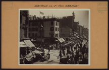
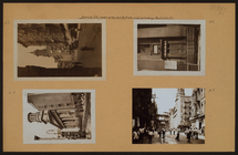
Manhattan: Hester Street - Es…
m
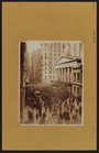
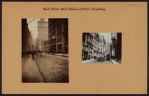
Manhattan: Wall Street
m
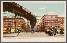
The Elevated at Eighth Avenue…
Freight terminal map of New Y…
Center of New York, first cit…
Hammond's new guide map of Ma…
Block line map of the heavy v…
m
Rand-McNally standard map of …
Williams' map of boroughs of …
Map of boroughs of Manhattan …
m
Hammond's new guide map of Ma…
m
Data for population from cens…
Upper Manhattan, comprising t…
The lower end of Manhattan Is…
Werpoes, a village of the Man…
Yorkville and East Harlem in …
H4. Map (Scheme B) illustrati…
m
Manhattan: 23rd Street (West)…
m
Manhattan: James Street - Mad…
m
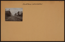
Manhattan: Wall Street - Will…
m
Manhattan: Broad Street - Exc…
m
Manhattan: 11th Avenue - 56th…
m
Manhattan: Beaver Street - Wi…
m
Manhattan: 8th Avenue - 31st …
m
Manhattan: 81st Street (West)…
m
Manhattan: 5th Avenue - 26th …
m
Manhattan: 119th Street (West…
m
Manhattan: Madison Avenue - 2…
m
Manhattan: Central Park - Mis…
m
Manhattan: St. Nicholas Avenu…
m
Manhattan: Morningside Avenue…
m
Manhattan: Morningside Avenue…
m
Manhattan: Madison Avenue - 2…
m
Manhattan: Central Park - Bet…
m
Manhattan: Central Park - The…
m
Manhattan: Polo grounds.
m
Manhattan: Madison Avenue - 2…
m
Manhattan: Manhattan Avenue -…
m
Manhattan: Broadway - 78th St…
m
Manhattan: Broadway - 77th St…
m
Manhattan: State Street - Bri…
m
Manhattan: Union Square - 14t…
m
Manhattan: Union Square - [Un…
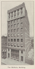
The McNulty Building, New York
m
Manhattan: 4th Avenue - 26th …
m
Manhattan: 2nd Ave. - 34th St…
m
Manhattan: 2nd Ave. - 48th St.
m
Manhattan: 5th Avenue - 43rd …
m
Manhattan: 5th Avenue - 43rd …
m
Manhattan: 5th Avenue - 43rd …
1
2
3
4
5
6
Previous
Next
1
2
3
4
5
6
Previous
Next