Click to visit the main New York Public Library Homepage
The New York Public Library
Digital Collections
About Digital Collections
Browse
Search only public domain materials
Items
Collections
Divisions
Home
Search
Browse
About
Search only public domain materials
Items
Collections
Divisions
Digital Collections
Using Images
Using Data
Search
Filtered search
Show filters
Hide filters
Show Only Public Domain
topic
Real property
572
Description and travel
113
Cities & towns
80
Fire insurance
80
Maps
41
More
Less
name
E. Belcher Hyde Map Company
241
E.B. Hyde & Co
241
Ullitz, Hugo
241
Century Map Company
111
Bromley, George Washington
102
More
Less
collection
Atlases of New York City
766
Atlases of the United States
221
Maps of New York City and State
106
Spezialkarte der Osterreichisch-Ungarischen Monarchie
72
Liberia
8
More
Less
place
New York (State)
589
New York
359
Brooklyn (New York, N.Y.)
292
Maps
244
New York (N.Y.)
192
More
Less
genre
x
Maps
Atlases
219
Topographic maps
164
Indexes
49
Cadastral maps
31
More
Less
publisher
E. Belcher Hyde
243
Sanborn Map Company
208
Century Map Company
111
G.W. Bromley & Co
102
K.u.K. Militargeographisches Institut
72
More
Less
division
Map Division
1139
Milstein Division
31
General Research Division
12
Schomburg Jean Blackwell Hutson Research and Reference Division
9
Manuscripts and Archives Division
7
More
Less
type
cartographic
1151
text
67
still image
3
Date Range
to
1,200 results found
Filtering on:
x
Date
: 1904 - 1907
x
Genre
: Maps
Sort by:
Title
Date created
Date digitized
Sequence
m
Map of property belonging to …
Map of Brooklyn Manor
m
Map of Brooklyn
Rand, McNally & Co.'s new aut…
Map and profile showing sourc…
Brooklyn
Rosedale Square, Rosedale : 4…
Map of Jamaica in the 4th war…
Railroad suburbs between Holl…
King's bird's-eye view of Bro…
Rand McNally standard map of …
East River Heights, first war…
Map of the borough of Brookly…
Hollis Terrace addition no. 1…
Map of 272 lots in the 30th w…
Map of Jamaica Fells : fourth…
m
Map of the borough of Brookly…
Rapid transit map of Kings, Q…
Brooklyn and vicinity
m
Map of the borough of Queens,…
m
View of the city of New York …
m
King's birds-eye view of Broo…
Topographical map showing str…
Map of Elmhurst Square : situ…
Freight terminal map of New Y…
The Merchants' Association's …
m
Map of New York : showing Leh…
Mapa de la ciudad de Nueva Yo…
m
Map of the underground railwa…
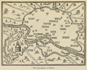
The description of Rome
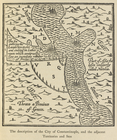
The description of the City o…
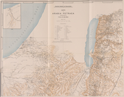
Die Karte von Arabia Petraea
Die Karte von Arabia Petraea
Situationsplan
m
Primorskai︠a︡ S.-Peterburgo-S…
m
N.Y.C. & H.R.R.R. Electric Zo…
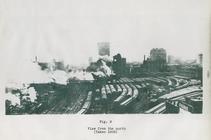
View from the north (figure 9)
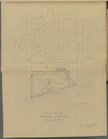
Plan for preservation of Audu…
Bounded by Avenue K., Ralph A…
Bounded by E. 103rd Street, A…
Bounded by Avenue D., Ralph A…
Bounded by Rockaway Avenue, R…
Bounded by Ralph Avenue, E. 9…
Bounded by Avenue J., E. 56th…
Bounded by Avenue P., E. 31st…
Bounded by Avenue V., Knapp S…
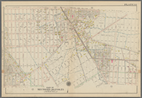
Coney Island, Plate 30
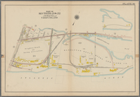
Coney Island. Bounded by Cana…
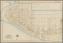
Bounded by Bay View Avenue, W…
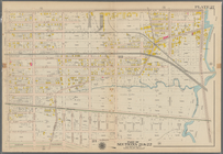
Bounded by Ocean Avenue, Emmo…
1
2
3
4
5
Previous
Next
1
2
3
4
5
Previous
Next