Click to visit the main New York Public Library Homepage
The New York Public Library
Digital Collections
About Digital Collections
Browse
Search only public domain materials
Items
Collections
Divisions
Home
Search
Browse
About
Search only public domain materials
Items
Collections
Divisions
Digital Collections
Using Images
Using Data
Search
Filtered search
Show filters
Hide filters
Show Only Public Domain
collection
Bancker plans
36
genre
x
Surveys
Maps
35
land surveys
31
Documents
6
division
Manuscripts and Archives Division
36
type
cartographic
35
text
6
Date Range
to
36 results found
Filtering on:
x
Date
: 1967 - 2017
x
Genre
: Surveys
Sort by:
Title
Date created
Date digitized
Sequence
m
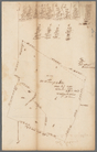
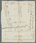
Land cleared near Mr. Apthorp…
m
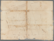
Wall Street
m
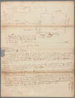
Stone Street
m
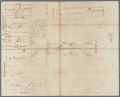
Mrs. Wever's lots in Queen St…
m
Little Queen, Crown and Cortl…
m
Kip's Bay
m
Now Ireland's, formerly schoo…
m
Survey of Lispenard land near…
m
James Delancey's lot and old …
m
Copy of a map of land at West…
m
Draft of the estate of the la…
m
Hospital, Broadway and Church…
m
Broadway and Fair Street
m
Northwest side of Broadway
m
Between Broadway, New Street,…
m
Survey of the Old House near …
m
Brevoort, Smith and Dawson's …
m
Richard Cunningham's ground a…
m
East side of Peck's Slip
m
Pearl Street
m
Old Slip
m
David Vance Smith
m
Brookland
m
Kings Bridge Road
m
Lewis A. Scott's farm at Gree…
m
Lot in Crown Street or Maiden…
m
King George Street
m
Gould Street near Maiden Lane
m
Fly Market
m
Division of eight lots
m
Survey of the cove at Corlear…
m
Catherine and Chapel Street
m
Broadway between George Harri…
m
Mandeville's near the Wey Land
m
Stoughton's bitters and mixtu…
m
John Devoor's farm made agree…
End of results
|
Top