Click to visit the main New York Public Library Homepage
The New York Public Library
Digital Collections
About Digital Collections
Browse
Search only public domain materials
Items
Collections
Divisions
Home
Search
Browse
About
Search only public domain materials
Items
Collections
Divisions
Digital Collections
Using Images
Using Data
Search
Filtered search
Show filters
Hide filters
Show Only Public Domain
topic
x
Planning
Streets
2
Eminent domain
1
Landowners
1
Real property
1
name
Davis, Thomas W. (Surveyor)
1
Meisel, A. (Augustus)
1
collection
Maps of New York City and State
1
Maps of North America
1
place
Boston
1
Boston (Mass.)
1
Manhattan (New York, N.Y.)
1
Massachusetts
1
New York (N.Y.)
1
More
Less
genre
Maps
2
Cadastral maps
1
Manuscript maps
1
publisher
City Surveyor
1
publisher not identified
1
division
x
Map Division
type
cartographic
2
Date Range
to
2 results found
Filtering on:
x
Division
: Map Division
x
Note
: A. L. S. Endorsed: "... receivd 21st July 1796 ..."
x
Topic
: Planning
Sort by:
Title
Date created
Date digitized
Sequence
Plan of Church St. district: …
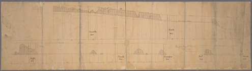
[Profile of 56th St. from Sev…