Click to visit the main New York Public Library Homepage
The New York Public Library
Digital Collections
About Digital Collections
Browse
Search only public domain materials
Items
Collections
Divisions
Home
Search
Browse
About
Search only public domain materials
Items
Collections
Divisions
Digital Collections
Using Images
Using Data
Search
Filtered search
Show filters
Hide filters
Show Only Public Domain
topic
Nautical charts
7
Atlases, British
3
Coasts
3
West Indies, British
2
Atlases
1
More
Less
name
Des Barres, Joseph F. W. (Joseph Frederick Wallet), 1729-1824
2
Godbid, Anne
2
Playford, John, ca. 1655-1685 or 6
2
Seller, John, fl. 1658-1698
2
Blunt, Edmund M. (Edmund March), 1770-1862
1
More
Less
collection
Lawrence H. Slaughter Collection of English maps, charts, globes, books and atlases
7
Maps of North America
2
place
x
Atlantic Coast (North America)
Caribbean Area
3
Maps
3
Early works to 1800
2
Mexico, Gulf of
2
More
Less
genre
Maps
9
publisher
Printed by A. Godbid and J. Playford, for John Seller ...,
2
Publish'd ... by I.F.W. Des Barres Esqr.,
2
And are to be sold at his shopps in Wapping at the Hermitage and in Exchange-Alley near the Royall-Exchange ..
1
Printed and sold by Wm. Herbert under the Piazzas on London Bridge & Robt. Sayer facing Fetter Lane, Fleet Street
1
Pub. by E.M. Blunt for W. Hooker
1
More
Less
division
x
Map Division
type
cartographic
9
Date Range
to
9 results found
Filtering on:
x
Division
: Map Division
x
Note
: Inscribed "to S. Watson from Johns Fergusson."
x
Place
: Atlantic Coast (North America)
Sort by:
Title
Date created
Date digitized
Sequence
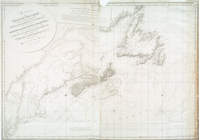
The coast of Nova Scotia, New…
The coast of Nova Scotia, New…
m
A chart of the West Indias fr…
Entrance to New York Bay from…
m
A chart of the West Indias fr…
A chart of the West Indies fr…
A chart of the Atlantick Ocea…
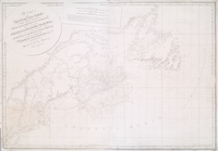
An actual survey of the sea c…
m
A new chart of the coast of A…