Click to visit the main New York Public Library Homepage
The New York Public Library
Digital Collections
About Digital Collections
Browse
Search only public domain materials
Items
Collections
Divisions
Home
Search
Browse
About
Search only public domain materials
Items
Collections
Divisions
Digital Collections
Using Images
Using Data
Search
Filtered search
Show filters
Hide filters
Show Only Public Domain
topic
x
Streets
City planning
2
Charts, diagrams, etc
1
Electric railroads
1
Geology
1
More
Less
name
Crofton, John
1
Hauz, William E
1
Page, J. Augustus, Esq
1
Rand McNally and Company
1
Willard Felt & Co
1
collection
Maps of New York City and State
5
place
New York (State)
5
Manhattan (New York, N.Y.)
4
New York (N.Y.)
4
New York
2
Brooklyn
1
More
Less
genre
Maps
5
Manuscript maps
2
Mass transit
1
Road maps
1
publisher
J. Augustus Page, Esq
1
The Company
1
Willard Felt & Co., Stationers, 17 and 19 Library Street
1
City Surveyor
1
division
x
Map Division
type
cartographic
5
Date Range
to
5 results found
Filtering on:
x
Division
: Map Division
x
Note
: Inscribed "to S. Watson from Johns Fergusson."
x
Topic
: Streets
Sort by:
Title
Date created
Date digitized
Sequence
Rand McNally & Co.'s new hand…
m
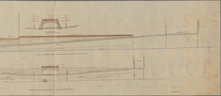
Profile of Riverside Drive fr…
m
Map showing the route for a p…
m
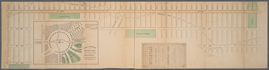
Map of the Boulevard : and pl…
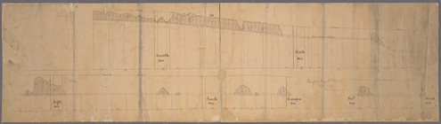
[Profile of 56th St. from Sev…