Click to visit the main New York Public Library Homepage
The New York Public Library
Digital Collections
About Digital Collections
Browse
Search only public domain materials
Items
Collections
Divisions
Home
Search
Browse
About
Search only public domain materials
Items
Collections
Divisions
Digital Collections
Using Images
Using Data
Search
Filtered search
Show filters
Hide filters
Show Only Public Domain
topic
Geography
3
Atlases
2
Atlases, British
2
Historical geography
2
Maps in education
2
More
Less
name
Thornton, Samuel
4
Dunn, Samuel, d. 1794
2
Faden, William, 1749-1836
2
Palmer, W. (William), 1739-1812
2
Sayer, Robert, 1725-1794
2
More
Less
collection
Atlases, gazetteers, guidebooks and other books
6
Lawrence H. Slaughter Collection of English maps, charts, globes, books and atlases
4
Maps of Europe
1
place
x
Ireland
Great Britain
3
Atlantic Ocean
2
England
2
Dublin (Ireland)
1
More
Less
genre
Maps
11
Nautical charts
4
publisher
Printed for Robert Sayer, No. 53, Fleet-Street
2
Published by Wm. Faden, geographer to His Majesty, and His R.H. the Prince of Wales
2
... Sold ... by Tho. Bowles, print and map-seller in St. Paul's-Churchyard
1
G.W. Bacon & Co
1
Printed for Ieames Shawe, and are to be solde at his shoppe nigh Ludgate,
1
division
x
Map Division
type
cartographic
11
Date Range
to
11 results found
Filtering on:
x
Division
: Map Division
x
Place term
: London
x
Place
: Ireland
Sort by:
Title
Date created
Date digitized
Sequence
Ireland divided into province…
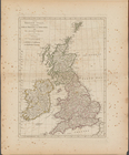
British Isles or Great Britai…
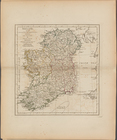
A new map of Ireland, divided…
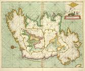
Hibernia.
The British Isles, comprehend…
Ireland, divided into its fou…
A new and correct chart of th…
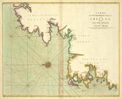
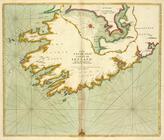
A chart of the NORTH-WEST coa…
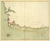
The SOUTH-WEST coast of IRELA…
The county of Waterford
m
Large scale plan of Dublin
End of results
|
Top