Click to visit the main New York Public Library Homepage
The New York Public Library
Digital Collections
About Digital Collections
Browse
Search only public domain materials
Items
Collections
Divisions
Home
Search
Browse
About
Search only public domain materials
Items
Collections
Divisions
Digital Collections
Using Images
Using Data
Search
Filtered search
Show filters
Hide filters
Show Only Public Domain
topic
Real property
9
Buildings
1
Estate
1
Fire prevention
1
Landowners
1
More
Less
name
G.W. Bromley & Co
7
Dyckman, Isaac
1
John Medole & Son
1
Major & Knapp Engraving, Manufacturing & Lithographic Co
1
collection
Atlases of New York City
7
Maps of New York City and State
3
place
x
New York (N.Y.)
Queens (New York, N.Y.)
7
Manhattan (New York, N.Y.)
3
New York (State)
3
New York
2
More
Less
genre
x
Cadastral maps
Maps
10
publisher
G. W. Bromley & Co
7
The Major & Knapp Eng. Mfg. & Lith. Co., 71 Broadway
1
publisher not identified
1
division
Map Division
10
type
cartographic
10
Date Range
to
10 results found
Filtering on:
x
Genre
: Cadastral maps
x
Note
: A. L. S. Endorsed: "... receivd 21st July 1796 ..."
x
Place
: New York (N.Y.)
Sort by:
Title
Date created
Date digitized
Sequence
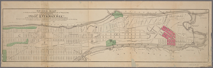
Guide map to 92 acres of land…
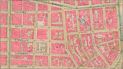
Mulberry Bend District. Map b…
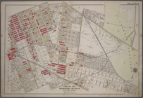
Property nos. 43, 45, and 47 …
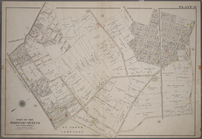
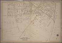
Plate 8: Bounded by Stanhope …
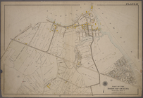
Plate 10: Bounded by Trotting…
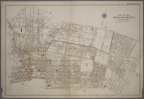
Plate 11: Bounded by Juniper …
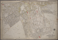
Plate 17: Bounded by Bowery B…
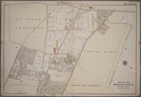
Plate 21: Bounded by (Mill Cr…
Plate 35: Bounded by Johnson …
Plate 39: Bounded by Chichest…