Click to visit the main New York Public Library Homepage
The New York Public Library
Digital Collections
About Digital Collections
Browse
Search only public domain materials
Items
Collections
Divisions
Home
Search
Browse
About
Search only public domain materials
Items
Collections
Divisions
Digital Collections
Using Images
Using Data
Search
Filtered search
Show filters
Hide filters
Show Only Public Domain
topic
Maps
3
Geography
2
Atlases
1
Atlases, British
1
History
1
More
Less
name
Chauchard, Captain
3
Gillet, Thomas
3
Neele, Samuel John, 1758-1824
3
Stockdale, John, 1749?-1814
3
Dunn, Samuel, d. 1794
1
More
Less
collection
Atlases, gazetteers, guidebooks and other books
4
Lawrence H. Slaughter Collection of English maps, charts, globes, books and atlases
1
Maps of Europe
1
The Political magazine and parliamentary, naval, military, and literary journal
1
place
x
Europe
Great Britain
3
Africa
1
London (England)
1
genre
x
Maps
Road maps
1
publisher
Printed for John Stockdale, Piccadilly. T. Gillett, Printer, Salisbury Square
3
Printed for Robert Sayer, No. 53, Fleet-Street
1
Chapman and Hall
1
Publisher not identified
1
printed for J. Murray
1
division
Map Division
6
General Research Division
1
type
cartographic
4
text
4
Date Range
to
7 results found
Filtering on:
x
Genre
: Maps
x
Language term
: English
x
Place
: Europe
Sort by:
Title
Date created
Date digitized
Sequence
World on gnomonic projection …
m
Reynolds' map of modern Londo…
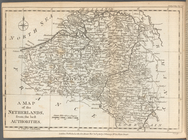
A Map of the Austrian, French…
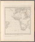
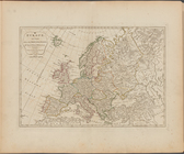
Europe divided into its princ…
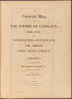
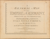
A general map of the empire o…
To the King's Most Excellent …
A general map of the empire o…