Click to visit the main New York Public Library Homepage
The New York Public Library
Digital Collections
About Digital Collections
Browse
Search only public domain materials
Items
Collections
Divisions
Home
Search
Browse
About
Search only public domain materials
Items
Collections
Divisions
Digital Collections
Using Images
Using Data
Search
Filtered search
Show filters
Hide filters
Show Only Public Domain
topic
Railroads
3
Boundaries
1
Cities and towns
1
Commerce
1
Counties
1
More
Less
name
Rand McNally and Company
3
Stone, William James, 1798-1865
2
Buell, Abel, 1742-1822
1
Fairfax, Wilson M. C
1
Graham, J. D. (James Duncan), 1799-1865
1
More
Less
collection
Maps of North America
6
I. N. Phelps Stokes Collection of American Historical Prints
2
place
x
Canada
United States
8
Maine
2
Mexico
2
New Brunswick
2
More
Less
genre
x
Maps
Prints
2
publisher
Rand, McNally & Co
2
John Wallis
1
Printed by order of the Senate of the U.S. of March 3d, 1843
1
Rand McNally & Co
1
W.J. Stone
1
More
Less
division
Map Division
6
Wallach Division: Print Collection
2
type
cartographic
8
Date Range
to
8 results found
Filtering on:
x
Genre
: Maps
x
Note
: Inscribed "to S. Watson from Johns Fergusson."
x
Place
: Canada
Sort by:
Title
Date created
Date digitized
Sequence
Map of the boundary lines bet…
Rand McNally & Co.'s new offi…
Rand McNally & Co.'s new offi…
Rand, McNally & Co.'s new com…
Extract from a map of the Bri…
m
New travelling and commercial…
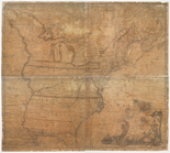
The United States of America …
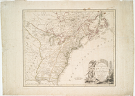
A new and correct map of the …