Click to visit the main New York Public Library Homepage
The New York Public Library
Digital Collections
About Digital Collections
Browse
Search only public domain materials
Items
Collections
Divisions
Home
Search
Browse
About
Search only public domain materials
Items
Collections
Divisions
Digital Collections
Using Images
Using Data
Search
Filtered search
Show filters
Hide filters
Show Only Public Domain
topic
Administrative and political divisions
4
Indians of North America
2
Colonies
1
Nautical charts
1
name
Andrews, Peter, active 1765-1782
4
Dury, Andrew
4
Montrésor, John, 1736-1799
4
Evans, Lewis, 1700?-1756
2
Gibson, J. (John)
2
More
Less
collection
Maps of North America
9
Maps of New York City and State
4
Lawrence H. Slaughter Collection of English maps, charts, globes, books and atlases
1
place
x
Northeastern States
New York (State)
7
America
5
Great Britain
5
Colonies
4
More
Less
genre
x
Maps
publisher
A. Dury ..
4
Printed for R. Phillips, 71 St. Paul's Church Yard
1
Printed for R. Sayer & J. Bennett, map, chart & printsellers, No. 53, Fleet Street ..
1
Printed for Robt. Sayer & John Bennett ..
1
Publish'd by Laurie & Whittle, 53 Fleet Street
1
More
Less
division
Map Division
14
type
cartographic
14
Date Range
to
14 results found
Filtering on:
x
Genre
: Maps
x
Place term
: London
x
Place
: Northeastern States
Sort by:
Title
Date created
Date digitized
Sequence
m
The provinces of New York, an…
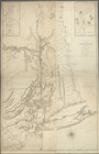
A map of the Province of New …
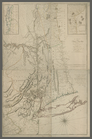
A map of the Province of New …
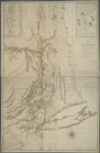
A map of the Province of New …
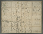
A map of the Province of New …
Map of the northern provinces…
A general map of the middle B…
United States of America, nor…
An accurate map of the Englis…
A new and general map of the …
A general map of the middle B…
A new and accurate map of New…
A general map of the middle B…
A New and correct map of the …
End of results
|
Top