Click to visit the main New York Public Library Homepage
The New York Public Library
Digital Collections
About Digital Collections
Browse
Search only public domain materials
Items
Collections
Divisions
Home
Search
Browse
About
Search only public domain materials
Items
Collections
Divisions
Digital Collections
Using Images
Using Data
Search
Filtered search
Show filters
Hide filters
Show Only Public Domain
topic
Fortification
1
History
1
name
American Civil War (1861-1865)
1
Horton, H. H
1
Price, Charles, active 1700-1707
1
Seller, Jeremiah
1
Seller, John, active 1658-1698
1
More
Less
collection
Lawrence H. Slaughter Collection of English maps, charts, globes, books and atlases
1
Maps of North America
1
place
x
Chesapeake Bay Region (Md. and Va.)
Virginia
2
Charleston Harbor (S.C.)
1
Florida
1
Maryland
1
More
Less
genre
x
Maps
publisher
Printed for Jer. Seller and Char. Price, at the Hermitage in Wapping
1
Published By James Wyld, Geographer To The Queen, 457 Strand; 11 & 12 Charing Cross East, & 2, Royal Exchange
1
division
Map Division
2
type
cartographic
2
Date Range
to
2 results found
Filtering on:
x
Genre
: Maps
x
Place term
: London
x
Place
: Chesapeake Bay Region (Md. and Va.)
Sort by:
Title
Date created
Date digitized
Sequence
Strategic war points of the U…
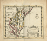
Virginia and Maryland