Click to visit the main New York Public Library Homepage
The New York Public Library
Digital Collections
About Digital Collections
Browse
Search only public domain materials
Items
Collections
Divisions
Home
Search
Browse
About
Search only public domain materials
Items
Collections
Divisions
Digital Collections
Using Images
Using Data
Search
Filtered search
Show filters
Hide filters
Show Only Public Domain
topic
Landowners
3
Real property
3
Boundaries
1
Buildings
1
Bulkheads
1
More
Less
name
Jones, Charles C. (Charles Colcock), 1831-1893
1
Knickerbocker Gas Light Co
1
United States. Army of the Cumberland
1
Van Winkle, Edgar B. (Edgar Beach), 1842-1920
1
collection
Maps of New York City and State
5
Maps of North America
4
place
Manhattan (New York, N.Y.)
4
New York (N.Y.)
4
New York (State)
4
Georgia
3
Cobb County (Ga.)
1
More
Less
genre
x
Manuscript maps
Maps
9
Cadastral maps
2
Surveys
1
Topographic maps
1
publisher
E. B. Van Winkle, Topographical Engineer, D. P. P
1
C. C. Jones, Jr
1
Department of Docks
1
Knickerbocker Gas Light Co
1
City Surveyor
1
More
Less
division
Map Division
9
type
cartographic
9
text
1
Date Range
to
9 results found
Filtering on:
x
Genre
: Manuscript maps
x
Note
: A. L. S. Endorsed: "... receivd 21st July 1796 ..."
x
Rights
: Public Domain
Sort by:
Title
Date created
Date digitized
Sequence
Georgia, parish of St. John :…
Map shewing position of 1st B…
m
Coll. John Bryerly's draught …
m
Position Army Cumbld., June 2…
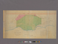
Map of New York City between …
Block bounded by 2nd Ave., 99…
Plan of High Bridge Park : pr…
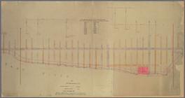
Map of water front from 61st …
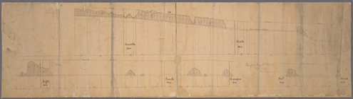
[Profile of 56th St. from Sev…