Click to visit the main New York Public Library Homepage
The New York Public Library
Digital Collections
About Digital Collections
Browse
Search only public domain materials
Items
Collections
Divisions
Home
Search
Browse
About
Search only public domain materials
Items
Collections
Divisions
Digital Collections
Using Images
Using Data
Search
Filtered search
Show filters
Hide filters
Show Only Public Domain
topic
Atlases, British
5
Coasts
2
West Indies, British
2
Atlases
1
Cities and towns
1
More
Less
name
Godbid, Anne
2
Playford, John, ca. 1655-1685 or 6
2
Seller, John, active 1658-1698
2
Seller, John, fl. 1658-1698
2
Thornton, Samuel
2
More
Less
collection
Lawrence H. Slaughter Collection of English maps, charts, globes, books and atlases
7
Atlases, gazetteers, guidebooks and other books
2
Maps of North America
1
place
x
Caribbean Area
Maps
4
Atlantic Coast (North America)
3
West Indies
3
Early works to 1800
2
More
Less
genre
x
Maps
Nautical charts
2
publisher
Printed by A. Godbid and J. Playford, for John Seller ...,
2
... Sold ... by Tho. Bowles, print and map-seller in St. Paul's-Churchyard
1
And are to be sold at his shopps in Wapping at the Hermitage and in Exchange-Alley near the Royall-Exchange ..
1
J. Seller
1
Printed by T.W. for R. Bonwicke, J. Walthoe, R. Wilkin, and T. Ward?,
1
More
Less
division
Map Division
10
type
cartographic
10
Date Range
to
10 results found
Filtering on:
x
Genre
: Maps
x
Place term
: London
x
Place
: Caribbean Area
Sort by:
Title
Date created
Date digitized
Sequence
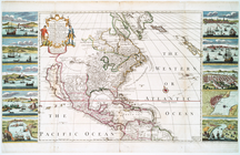
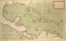
A new & correct map of the tr…
m
A chart of the West Indias fr…
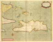
m
A chart of the West Indias fr…
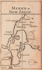
Mexico, or, New Spain
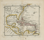
The Western Ilands
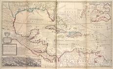
A chart of the West Indies fr…
A map of the West-Indies or t…
A new map of North America sh…
A new and correct large draug…
A chart of the Iland of HISPA…