Click to visit the main New York Public Library Homepage
The New York Public Library
Digital Collections
About Digital Collections
Browse
Search only public domain materials
Items
Collections
Divisions
Home
Search
Browse
About
Search only public domain materials
Items
Collections
Divisions
Digital Collections
Using Images
Using Data
Search
Filtered search
Show filters
Hide filters
Show Only Public Domain
topic
x
Nautical charts
Coasts
2
Fortification
2
name
Des Barres, Joseph F. W. (Joseph Frederick Wallet), 1729-1824
2
Bew, John, -1793
1
Bew, John, d. 1793
1
Keulen, Johannes van, 1654-1715
1
Lodge, John, -1796
1
More
Less
collection
I. N. Phelps Stokes Collection of American Historical Prints
2
Lawrence H. Slaughter Collection of English maps, charts, globes, books and atlases
2
Cartographic materials from the Emmet collection of manuscripts etc. relating to American history
1
Maps of New York City and State
1
place
x
New York (N.Y.)
Long Island (N.Y.)
6
New Jersey
3
Long Island Sound (N.Y. and Conn.)
2
Manhattan (New York, N.Y.)
2
More
Less
genre
Maps
6
Prints
2
Early works to 1800
1
publisher
Published for the use of the Royal Navy of Great Britain by Joseph F. W. Des Barres
2
Published ... by J. Bew
1
Published ... by J. Bew, Pater Noster Row
1
division
Map Division
4
Wallach Division: Print Collection
2
type
cartographic
6
still image
1
Date Range
to
6 results found
Filtering on:
x
Place
: New York (N.Y.)
x
Place
: Long Island (N.Y.)
x
Topic
: Nautical charts
Sort by:
Title
Date created
Date digitized
Sequence
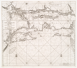
[A chart of New York Island &…
A chart of New York Island & …
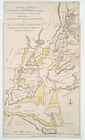
Chart and plan of the harbour…
Pas-kaart vande zee kusten va…
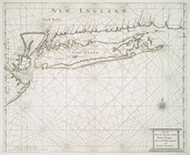
Part of New England New York …
Chart and plan of the harbour…