Click to visit the main New York Public Library Homepage
The New York Public Library
Digital Collections
About Digital Collections
Browse
Search only public domain materials
Items
Collections
Divisions
Home
Search
Browse
About
Search only public domain materials
Items
Collections
Divisions
Digital Collections
Using Images
Using Data
Search
Filtered search
Show filters
Hide filters
Show Only Public Domain
topic
History
5
Harbors
3
Slavery
2
Administrative and political divisions
1
African Americans
1
More
Less
name
American Revolution (1775-1783)
2
Robert Sayer and John Bennett (Firm)
2
American Civil War (1861-1865)
1
Clinton, Henry, Sir, 1738?-1795
1
Crowe, Eyre, 1824-1910
1
More
Less
collection
Maps of North America
7
Archibald Robertson: his diaries and sketches in America, 1762-1780
1
Men of mark: eminent, progressive and rising
1
Print Collection
1
place
x
United States
Charleston (S.C.)
10
South Carolina
7
Charleston
5
North Carolina
3
More
Less
genre
Maps
8
Illustrations
1
Manuscripts
1
Portraits
1
Prints
1
publisher
A.J. Johnson
1
C.P. Wayne
1
Cleveland, O
1
Philip Lea
1
Printed and sold by William Faden, successor to the late Mr. Thomas Jefferys, geographer to the King, the corner of St. Martin's Lane, Charing Cross
1
More
Less
division
Map Division
7
Schomburg Jean Blackwell Hutson Research and Reference Division
1
Schomburg Photographs and Prints Division
1
Spencer Collection
1
type
cartographic
8
still image
3
Date Range
to
10 results found
Filtering on:
x
Place
: United States
x
Place
: Charleston (S.C.)
x
Rights
: Public Domain
Sort by:
Title
Date created
Date digitized
Sequence
New map of Charleston Harbor:…
A new map of Carolina
Johnson's North Carolina and …
Plan of the siege of Charlest…
A plan of the attack of Fort …
m
An accurate map of North and …
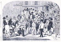
Slave sale, Charleston, South…
A general map of the southern…
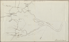
Map of Charleston Neck, South…
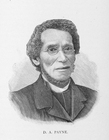
D. A. Payne