Click to visit the main New York Public Library Homepage
The New York Public Library
Digital Collections
About Digital Collections
Browse
Search only public domain materials
Items
Collections
Divisions
Home
Search
Browse
About
Search only public domain materials
Items
Collections
Divisions
Digital Collections
Using Images
Using Data
Search
Filtered search
Show filters
Hide filters
Show Only Public Domain
topic
Administrative and political divisions
2
Early works to 1800
2
Maps
2
Travel
2
Facsimiles
1
More
Less
name
Pownall, Thomas, 1722-1805
3
Brodhead, John Romeyn, 1814-1873
2
Hendricxz, Cornelis
2
Holland, Samuel, 1728-1801
2
Lotter, Matthäus Albrecht, 1741-1810
2
More
Less
collection
Lawrence H. Slaughter Collection of English maps, charts, globes, books and atlases
3
Maps of North America
3
Maps of New York City and State
2
The gospel of slavery: a primer of freedom
1
place
x
Northeastern States
New York (State)
6
New Jersey
5
Pennsylvania
4
Québec (Province)
3
More
Less
genre
Maps
8
Early maps
2
Facsimiles
2
Illustrations
1
publisher
M. A. Lotter
2
publisher not identified
2
Printed for R. Sayer & J. Bennett, map, chart & printsellers, No. 53, Fleet Street ..
1
Printed for Robt. Sayer & John Bennett ..
1
Published by Harry Lodowick Broenner ..
1
More
Less
division
Map Division
8
Schomburg Manuscripts, Archives and Rare Books Division
1
type
cartographic
8
still image
1
text
1
Date Range
to
9 results found
Filtering on:
x
Language term
: English
x
Place
: Northeastern States
Sort by:
Title
Date created
Date digitized
Sequence
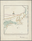
Nieu Nederlandt
m
Niev Nederlandt
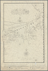
The provinces of New York, an…
A map of the provinces of New…
m
The provinces of New York, an…
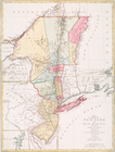
A general map of the middle B…
A general map of the middle B…
A map of the provinces of New…
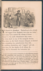
Y stands for Yankee.