Click to visit the main New York Public Library Homepage
The New York Public Library
Digital Collections
About Digital Collections
Browse
Search only public domain materials
Items
Collections
Divisions
Home
Search
Browse
About
Search only public domain materials
Items
Collections
Divisions
Digital Collections
Using Images
Using Data
Search
Filtered search
Show filters
Hide filters
Show Only Public Domain
topic
x
Maps
Real property
5
Insurance, Fire
1
Landowners
1
name
G.W. Bromley & Co
7
Bromley, George Washington
3
Bromley, Walter Scott
3
M.B. Brown Printing and Binding Co
1
New York (N.Y.). Board of Estimate and Apportionment
1
More
Less
collection
Atlases of New York City
9
Maps of North America
1
place
New York (N.Y.)
5
Bronx (New York, N.Y.)
4
Brooklyn (New York, N.Y.)
4
New York (State)
4
New Jersey
1
More
Less
genre
Maps
10
Manuscript maps
1
Surveys
1
publisher
G.W. Bromley & Co
7
M.B. Brown Printing & Binding Co.,
1
William Perris
1
division
Map Division
10
type
cartographic
10
Date Range
to
10 results found
Filtering on:
x
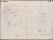
Note
: "Pl. 34"--lettered on border.
x
Topic
: Maps
Sort by:
Title
Date created
Date digitized
Sequence
Bounded by Avenue P., E. 31st…
Bounded by Mackay Pl., 1st Av…
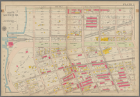
Bounded by 60th St., Seventh …
m
Draught of 8 3/4 acres of lan…
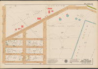
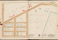
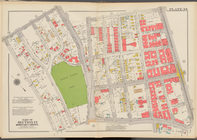
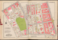
Double Page Plate No. 34, Par…
Double Page Plate No. 34, Par…
Plate 34: Map bounded by Carr…
Double Page Plate No. 34, Par…
Double Page Plate No. 34, Par…
Area District Map Section No.…