Click to visit the main New York Public Library Homepage
The New York Public Library
Digital Collections
About Digital Collections
Browse
Search only public domain materials
Items
Collections
Divisions
Home
Search
Browse
About
Search only public domain materials
Items
Collections
Divisions
Digital Collections
Using Images
Using Data
Search
Filtered search
Show filters
Hide filters
Show Only Public Domain
topic
x
Streets
Local transit
14
Railroads, Elevated
7
Administrative and political divisions
3
Trolley cars
3
More
Less
name
Matthews-Northrup Works
3
Trow Directory, Printing and Bookbinding Company
3
C.S. Hammond & Company
2
Rand McNally and Company
2
American Photo-Eng. Co
1
More
Less
collection
Maps of New York City and State
14
place
x
New York
New York (State)
14
Brooklyn (New York, N.Y.)
10
New York (N.Y.)
8
Manhattan (New York, N.Y.)
7
More
Less
genre
Maps
14
Mass transit
2
Road maps
2
publisher
Matthews-Northrup Works
2
The Company
2
A. B. Cohn
1
A.G. Hagstrom Co
1
Alfred Vischer & Co
1
More
Less
division
Map Division
14
type
cartographic
14
Date Range
to
14 results found
Filtering on:
x
Place
: New York
x
Topic
: Streets
x
Topic
: Local transit
Sort by:
Title
Date created
Date digitized
Sequence
m
Hammond's complete map of Bro…
m
Map of the borough of Brookly…
Rand McNally Map of Brooklyn
m
New quick reference street in…
m
Hammond's complete map of Bro…
Rand McNally & Co.'s new hand…
m
New guide map of New York Cit…
Williams' map of boroughs of …
m
Hagstrom's map of Brooklyn (N…
Pocket map of Broadway, New Y…
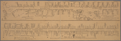
The largest and grandest comm…
m
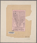
Map of the northern part of t…
Map of the northern part of t…
Map of the southern part of t…
End of results
|
Top