Click to visit the main New York Public Library Homepage
The New York Public Library
Digital Collections
About Digital Collections
Browse
Search only public domain materials
Items
Collections
Divisions
Home
Search
Browse
About
Search only public domain materials
Items
Collections
Divisions
Digital Collections
Using Images
Using Data
Search
Filtered search
Show filters
Hide filters
Show Only Public Domain
topic
History
2
Indians of North America
2
Capitols
1
Forts & fortifications
1
Nautical charts
1
More
Less
name
American Revolution (1775-1783)
2
Evans, Lewis, 1700?-1756
2
Fenner, Sears & Co
2
Bew, John, -1793
1
Blaskowitz, Charles
1
More
Less
collection
Maps of North America
6
Emmet Collection of Manuscripts Etc. Relating to American History
2
Lawrence H. Slaughter Collection of English maps, charts, globes, books and atlases
1
place
x
Rhode Island
Connecticut
5
New York (State)
3
Newport (R.I.)
3
Pennsylvania
3
More
Less
genre
Maps
7
Prints
2
Early maps
1
Nautical charts
1
publisher
I. T. Hinton & Simpkin & Marshall
1
J. Bew
1
John Hinton
1
Laurie & Whittle
1
Printed for the proprietor Carington Bowles No. 69 in St. Pauls Church Yard,
1
More
Less
division
Map Division
7
Wallach Division: Print Collection
2
type
cartographic
7
still image
2
Date Range
to
9 results found
Filtering on:
x
Place term
: London
x
Place
: Rhode Island
Sort by:
Title
Date created
Date digitized
Sequence
m
A chart of the harbour of Rho…
A plan of the town of Newport…
An accurate map of Rhode Isla…
A new and accurate map of Con…
m
A map of Cabotia: comprehendi…
Bowles's new pocket map of th…
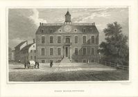
State House, Newport.
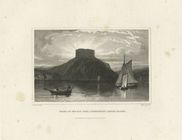
Ruins of the old fort, Connan…
A general map of the middle B…