Click to visit the main New York Public Library Homepage
The New York Public Library
Digital Collections
About Digital Collections
Browse
Search only public domain materials
Items
Collections
Divisions
Home
Search
Browse
About
Search only public domain materials
Items
Collections
Divisions
Digital Collections
Using Images
Using Data
Search
Filtered search
Show filters
Hide filters
Show Only Public Domain
topic
x
Canals
Administrative and political divisions
8
Maps
6
Railroads
5
Altitudes
3
More
Less
name
Disturnell, John, 1801-1877
5
Sherman & Smith
5
Smith, J. Calvin (John Calvin)
5
Colden, Cadwallader D. (Cadwallader David) (1769-1834)
3
Stone, William L. (William Leete) (1792-1844)
3
More
Less
collection
Maps of New York City and State
8
Memoir, prepared at the request of a committee of the Common council of the city of New York, and presented to the mayor of the city, at the celebration of the completion of the New York canals
3
Atlases of the United States
1
place
x
New York (State)
New York (N.Y.)
7
Erie Canal (N.Y.)
4
Manhattan (New York, N.Y.)
2
Canal Street (New York, N.Y.)
1
More
Less
genre
Maps
9
Illustrations
3
Prints
3
Atlases
1
Road maps
1
More
Less
publisher
Printed by order of the corporation of New York
3
J. Disturnell
2
Published by J. Disturnell, 102 Broadway
2
D. H. Burr
1
J. Disturnell,
1
More
Less
division
Map Division
9
Wallach Division: Print Collection
3
type
cartographic
9
still image
3
Date Range
to
12 results found
Filtering on:
x
Place term
: New York
x
Place
: New York (State)
x
Topic
: Canals
Sort by:
Title
Date created
Date digitized
Sequence
Distance map of the state of …
Map of the state of New York …
Map of the State of New York …
Map of the state of New York …
Map of the state of New York …
Map of the state of New York …
Distance map of the state of …
Map of the state of New York …
Map of the state of New-York …
Junction of the Northern and …
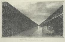
Deep cutting, Lockport.
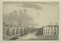
Perspective view of Canal Str…
End of results
|
Top