


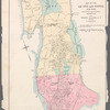
![Plate 1: Map No. 441 [Bounded by Fourth Avenue, 138th Street, ... (Harlem River) Line of Water Grant, Bulkhead & Pier Line, Grove Street, Cottage Street, Old Boston Post Road or Morris Avenue.]](https://images.nypl.org/index.php?id=1524170&t=b)
![Plate 2: Map No. 419 [Bounded by 138th Street, Mill Brook, 131st Street, Morris Avenue, 130th Street, Harlem River High Water Line and Third Avenue.]](https://images.nypl.org/index.php?id=1524171&t=b)
![Plate 3: Map No. 549 [Bounded by 4th Avenue (130th to 141st Sts.), River Avenue, 146th Street, College Rider Avenue, 138th Street, Third Avenueand 130th Street.]](https://images.nypl.org/index.php?id=1524172&t=b)
![Plate 4: Map No. 302 [Bounded by Harlem River, [149th Street] and Post Road from New York to Boston.]- Map No. 549 [Bounded by Grove St., Cottage St., Villa Place, Old Boston Road, 130th Street, 4th Avenue, Macomb Avenue and Walton Avenue.]](https://images.nypl.org/index.php?id=1524173&t=b)
![Plate 5: Map No. 375 [Bounded by Fourth Avenue, Riverside Avenue, Macomb Avenue, Cottage Street, Morris Avenue, 3rd Avenue and 129th Street.] - Map No. 213 [Bounded by Cherry Street, Old Harlem Bridge Post Road from New York to Boston, Harlem River and New bridge.]](https://images.nypl.org/index.php?id=1524174&t=b)
![Plate 6: Map No. 141 [Bounded by James Street, (Wm. Morris Farm), Rail Road Avenue, Prospect Street, Juliet Street, Gerard Street, Henry Street and River Avenue.]- Map No. 286 {Bounded by James WElls Land, Mill Brook, Henry Street and Morse Avenue or Old Boston Road.]](https://images.nypl.org/index.php?id=1524175&t=b)
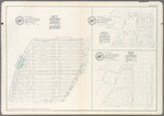
![Plate 7: Map No. 148 [Bounded by Ella St., Rail Road Ave., Juliet St., and Morrisania Av.] - Map No. 509: [Bounded by (West Morrisania) Melrose Street, Morris St., Mott St. and Harlem River.] - Map No. 242: [Bounded by Cortland Ave., First St., Rail Road Ave. and William St.]](https://images.nypl.org/index.php?id=1524176&t=b)
![Plate 9: Map No. 641, old No. 143 [Bounded by Rail Road Ave., Fighth St., Franklin Ave., Jefferson St., Morse Ave. and Fordham Ave.] -Map No. 602: [Bounded by Jackson Ave., 156th St. and Westchester Ave.] -Map No. 207: [Bounded by Morse Ave., East Sixth St. and Union Ave.] -Map No. 249: [Bounded by Morse Ave., Sixth St. and Union Ave.]](https://images.nypl.org/index.php?id=1524178&t=b)
![Plate 10: Map No. 541 [Bounded by Wall St., (Woodstock) Grove Ave, (Grove Hill) Cliff St., Carr Ave.and Boston Road.] - Map No. 195: [Bounded by Village of Fairmount, Grove St., Oak St. znc Prospect Ave.] - Map No. 373: [Bounded by Wall St., Union Ave., New St. and Forest Ave.]](https://images.nypl.org/index.php?id=1524179&t=b)
![Plate 11: Map No. 165 [Bounded by 3 Rod Road, Coles Road and Southern Westchester Turnpike.] - Map No. 232: [Bounded by 6th St., Prospect Ave., Road leading from the Harlem Bridge to the Village of Westchester, Post Road and Railroad Avenue.]](https://images.nypl.org/index.php?id=1524180&t=b)
![Plate 12: Map No. 149 [Bounded by Harlem River (River Ave.), James St., Washington Ave. (Village of Morrisania) and Juliet St.] - Map No. 140: [Bounded by Harlem Rail Road, Upper Morrisania, and Morrisania Village.]](https://images.nypl.org/index.php?id=1524181&t=b)
- The Library Shop
- Privacy Policy
- Rules and Regulations
- Using the Internet
- Website Terms and Conditions
- Gifts of Materials to NYPL
-
© The New York Public Library, 2025
The New York Public Library is a 501(c)(3) | EIN 13-1887440
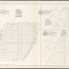
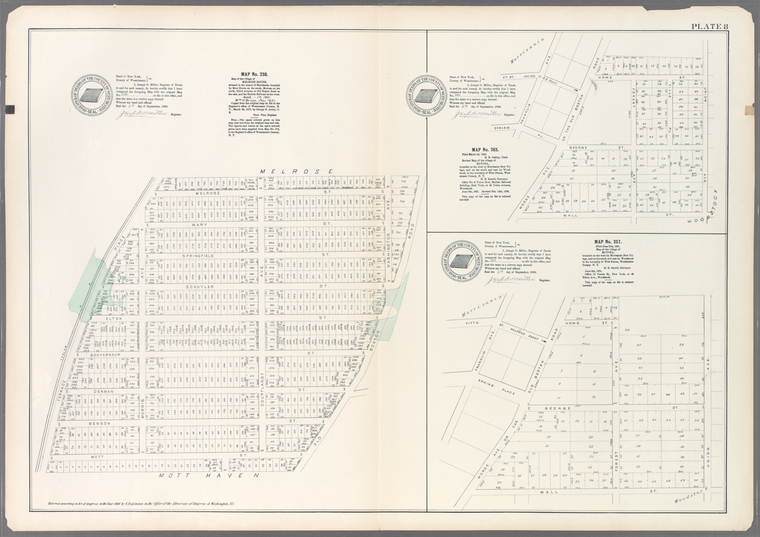
Lionel Pincus and Princess Firyal Map Division, The New York Public Library. "Plate 8: Map No. 238, Bounded by Mott Haven on the south, Melrose on the north, Third Avenue or Old Boston Road on the east, and the Harlem Railroad on the west. - Map No. 265: Bounded on the west by Morrisania New Village, and on the south and east by Woodstock, in the township of West Farms, Westchester County, N.Y. - Map No. 257: Bounded on the west by Morrisania New Village, and on the south and east by Woodstock in the township of West Farms, Westchester County, N.Y." The New York Public Library Digital Collections. 1888 - 1897. https://digitalcollections.nypl.org/items/510d47e2-4a2d-a3d9-e040-e00a18064a99
Lionel Pincus and Princess Firyal Map Division, The New York Public Library. "Plate 8: Map No. 238, Bounded by Mott Haven on the south, Melrose on the north, Third Avenue or Old Boston Road on the east, and the Harlem Railroad on the west. - Map No. 265: Bounded on the west by Morrisania New Village, and on the south and east by Woodstock, in the township of West Farms, Westchester County, N.Y. - Map No. 257: Bounded on the west by Morrisania New Village, and on the south and east by Woodstock in the township of West Farms, Westchester County, N.Y." New York Public Library Digital Collections. Accessed March 14, 2025. https://digitalcollections.nypl.org/items/510d47e2-4a2d-a3d9-e040-e00a18064a99
Lionel Pincus and Princess Firyal Map Division, The New York Public Library. (1888 - 1897). Plate 8: Map No. 238, Bounded by Mott Haven on the south, Melrose on the north, Third Avenue or Old Boston Road on the east, and the Harlem Railroad on the west. - Map No. 265: Bounded on the west by Morrisania New Village, and on the south and east by Woodstock, in the township of West Farms, Westchester County, N.Y. - Map No. 257: Bounded on the west by Morrisania New Village, and on the south and east by Woodstock in the township of West Farms, Westchester County, N.Y. Retrieved from https://digitalcollections.nypl.org/items/510d47e2-4a2d-a3d9-e040-e00a18064a99
<ref name=NYPL>{{cite web | url=https://digitalcollections.nypl.org/items/510d47e2-4a2d-a3d9-e040-e00a18064a99 | title=
(cartographic)
Plate 8: Map No. 238, Bounded by Mott Haven on the south, Melrose on the north, Third Avenue or Old Boston Road on the east, and the Harlem Railroad on the west. - Map No. 265: Bounded on the west by Morrisania New Village, and on the south and east by Woodstock, in the township of West Farms, Westchester County, N.Y. - Map No. 257: Bounded on the west by Morrisania New Village, and on the south and east by Woodstock in the township of West Farms, Westchester County, N.Y., (1888 - 1897)
|author=Digital Collections, The New York Public Library |accessdate=March 14, 2025 |publisher=The New York Public Library, Astor, Lenox, and Tilden Foundations}}</ref>