


![Plate 1: Map No. 441 [Bounded by Fourth Avenue, 138th Street, ... (Harlem River) Line of Water Grant, Bulkhead & Pier Line, Grove Street, Cottage Street, Old Boston Post Road or Morris Avenue.]](https://images.nypl.org/index.php?id=1524170&t=b)
![Plate 2: Map No. 419 [Bounded by 138th Street, Mill Brook, 131st Street, Morris Avenue, 130th Street, Harlem River High Water Line and Third Avenue.]](https://images.nypl.org/index.php?id=1524171&t=b)
![Plate 3: Map No. 549 [Bounded by 4th Avenue (130th to 141st Sts.), River Avenue, 146th Street, College Rider Avenue, 138th Street, Third Avenueand 130th Street.]](https://images.nypl.org/index.php?id=1524172&t=b)
![Plate 4: Map No. 302 [Bounded by Harlem River, [149th Street] and Post Road from New York to Boston.]- Map No. 549 [Bounded by Grove St., Cottage St., Villa Place, Old Boston Road, 130th Street, 4th Avenue, Macomb Avenue and Walton Avenue.]](https://images.nypl.org/index.php?id=1524173&t=b)
![Plate 5: Map No. 375 [Bounded by Fourth Avenue, Riverside Avenue, Macomb Avenue, Cottage Street, Morris Avenue, 3rd Avenue and 129th Street.] - Map No. 213 [Bounded by Cherry Street, Old Harlem Bridge Post Road from New York to Boston, Harlem River and New bridge.]](https://images.nypl.org/index.php?id=1524174&t=b)
![Plate 6: Map No. 141 [Bounded by James Street, (Wm. Morris Farm), Rail Road Avenue, Prospect Street, Juliet Street, Gerard Street, Henry Street and River Avenue.]- Map No. 286 {Bounded by James WElls Land, Mill Brook, Henry Street and Morse Avenue or Old Boston Road.]](https://images.nypl.org/index.php?id=1524175&t=b)
![Plate 7: Map No. 148 [Bounded by Ella St., Rail Road Ave., Juliet St., and Morrisania Av.] - Map No. 509: [Bounded by (West Morrisania) Melrose Street, Morris St., Mott St. and Harlem River.] - Map No. 242: [Bounded by Cortland Ave., First St., Rail Road Ave. and William St.]](https://images.nypl.org/index.php?id=1524176&t=b)
![Plate 9: Map No. 641, old No. 143 [Bounded by Rail Road Ave., Fighth St., Franklin Ave., Jefferson St., Morse Ave. and Fordham Ave.] -Map No. 602: [Bounded by Jackson Ave., 156th St. and Westchester Ave.] -Map No. 207: [Bounded by Morse Ave., East Sixth St. and Union Ave.] -Map No. 249: [Bounded by Morse Ave., Sixth St. and Union Ave.]](https://images.nypl.org/index.php?id=1524178&t=b)
![Plate 10: Map No. 541 [Bounded by Wall St., (Woodstock) Grove Ave, (Grove Hill) Cliff St., Carr Ave.and Boston Road.] - Map No. 195: [Bounded by Village of Fairmount, Grove St., Oak St. znc Prospect Ave.] - Map No. 373: [Bounded by Wall St., Union Ave., New St. and Forest Ave.]](https://images.nypl.org/index.php?id=1524179&t=b)
![Plate 11: Map No. 165 [Bounded by 3 Rod Road, Coles Road and Southern Westchester Turnpike.] - Map No. 232: [Bounded by 6th St., Prospect Ave., Road leading from the Harlem Bridge to the Village of Westchester, Post Road and Railroad Avenue.]](https://images.nypl.org/index.php?id=1524180&t=b)
![Plate 12: Map No. 149 [Bounded by Harlem River (River Ave.), James St., Washington Ave. (Village of Morrisania) and Juliet St.] - Map No. 140: [Bounded by Harlem Rail Road, Upper Morrisania, and Morrisania Village.]](https://images.nypl.org/index.php?id=1524181&t=b)
![Atlas of city of New York Borough of the Bronx. Sections 9 & 10. From actual surveys and official plans by George W. and Walter &. Bromley, Civil Engineers [title page]](https://images.nypl.org/index.php?id=2020866&t=b)
![Plate 1 [Map bounded by E. 135th St., East River, Bronx River, Cypress Ave]](https://images.nypl.org/index.php?id=2020869&t=b)
![Plate 2 [Map bounded by E. 135th St., Cypress Ave., Bronx kills, Willis Ave.]](https://images.nypl.org/index.php?id=2020870&t=b)
![Plate 3 [Map bounded by E. 135th St., Willis Ave., Harlem River, Park Ave.]](https://images.nypl.org/index.php?id=2020871&t=b)
![Plate 4 [Map bounded by E. 141st St., E. 142nd St., E. 135th St., Harlem River]](https://images.nypl.org/index.php?id=2020872&t=b)
![Plate 5 [Map bounded by E. 142nd St., Cypress Ave., E. 135th St.]](https://images.nypl.org/index.php?id=2020873&t=b)
![Plate 6 [Map bounded by E. 141st St., East River, E. 135th St., Cypress Ave.]](https://images.nypl.org/index.php?id=2020874&t=b)
![Plate 7 [Map bounded by Dater St., E. 147th St., Whitlock Ave., E. 141st St., St. Anns Ave.]](https://images.nypl.org/index.php?id=2020875&t=b)
![Plate 8 [Map bounded by E. 149th St., St. Anns. Ave., E. 142nd St., Morris Ave.]](https://images.nypl.org/index.php?id=2020876&t=b)
![Plate 9 [Map bounded by E. 150th St., Morris Ave., Cheever Pl., Harlem River]](https://images.nypl.org/index.php?id=2020877&t=b)
![Plate 10 [Map bounded by Harlem River, E. 161st St., Gerard Ave.]](https://images.nypl.org/index.php?id=2020878&t=b)
![Plate 11 [Map bounded by Gerard Ave., E. 161st St., Morris Ave., E. 150th St.]](https://images.nypl.org/index.php?id=2020879&t=b)
![Atlas of the city of New York Borough of the Bronx. Annexed District. From actual surveys and official plans by George W. and Walter S. Bromley, civil Engineers [title page]](https://images.nypl.org/index.php?id=2021295&t=b)
![Outline and Index Map of the Borough of the Bronx, Sections 14, 15, 16, 17 and 18, Bronx Annex [continued]](https://images.nypl.org/index.php?id=2021298&t=b)
![Plate 1 [Map bounded by E. 213th St., Lurting Ave., Burke Ave., Bronx River]](https://images.nypl.org/index.php?id=2021300&t=b)
![Plate 2 [Map bounded by E. 221st St., Corsa Lane Rd., Givan Ave., Gun Hill Rd., E. 213th St., Barnes Ave.]](https://images.nypl.org/index.php?id=2021301&t=b)
![Plate 3 [Map bounded by Webster Ave., E. 225th St., Barnes Ave., E. 213th St.]](https://images.nypl.org/index.php?id=2021302&t=b)
![Plate 4 [Map bounded by Barnes Ave., E. 233th St., Laconia Ave., E. 219th St.]](https://images.nypl.org/index.php?id=2021303&t=b)
![Plate 5 [Map bounded by Bronx River, Nereid Ave., Barnes Ave., E. 226th St.]](https://images.nypl.org/index.php?id=2021304&t=b)
![Plate 6 [Map bounded by Bronx River, 243rd St., Barnes Ave., Nereid Ave.]](https://images.nypl.org/index.php?id=2021305&t=b)
![Plate 7 [Map bounded by Penfield St., Seton Ave., Pitman Ave., Barnes Ave.]](https://images.nypl.org/index.php?id=2021306&t=b)
![Plate 8 [Map bounded by Pitman Ave., Seton Ave., Strang Ave., E. 233rd St.]](https://images.nypl.org/index.php?id=2021307&t=b)
![Plate 9 [Map bounded by Strang Ave., Murdock Ave., Eden Terrace, Needham Ave., Corsa Lane]](https://images.nypl.org/index.php?id=2021308&t=b)
![Plate 10 [Map bounded by Dark St., Boston Rd., Eden Terrace, Murdock Ave.]](https://images.nypl.org/index.php?id=2021309&t=b)
- The Library Shop
- Privacy Policy
- Rules and Regulations
- Using the Internet
- Website Terms and Conditions
- Gifts of Materials to NYPL
-
© The New York Public Library, 2025
The New York Public Library is a 501(c)(3) | EIN 13-1887440
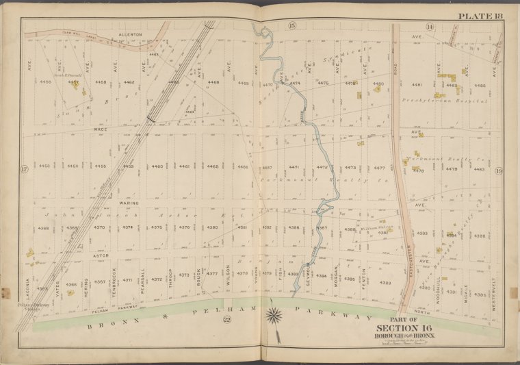
![Plate 18 [Map bounded by Allerton Ave., Westervelt Ave., Bronx & Pelham Parkway, Laconia Ave.]](https://images.nypl.org/index.php?id=2021317&t=b)
Lionel Pincus and Princess Firyal Map Division, The New York Public Library. "Plate 18 [Map bounded by Allerton Ave., Westervelt Ave., Bronx & Pelham Parkway, Laconia Ave.]" The New York Public Library Digital Collections. 1913. https://digitalcollections.nypl.org/items/a1ed00e6-62a4-12d0-e040-e00a1806506b
Lionel Pincus and Princess Firyal Map Division, The New York Public Library. "Plate 18 [Map bounded by Allerton Ave., Westervelt Ave., Bronx & Pelham Parkway, Laconia Ave.]" New York Public Library Digital Collections. Accessed February 13, 2025. https://digitalcollections.nypl.org/items/a1ed00e6-62a4-12d0-e040-e00a1806506b
Lionel Pincus and Princess Firyal Map Division, The New York Public Library. (1913). Plate 18 [Map bounded by Allerton Ave., Westervelt Ave., Bronx & Pelham Parkway, Laconia Ave.] Retrieved from https://digitalcollections.nypl.org/items/a1ed00e6-62a4-12d0-e040-e00a1806506b
<ref name=NYPL>{{cite web | url=https://digitalcollections.nypl.org/items/a1ed00e6-62a4-12d0-e040-e00a1806506b | title=
(cartographic)
Plate 18 [Map bounded by Allerton Ave., Westervelt Ave., Bronx & Pelham Parkway, Laconia Ave.], (1913)
|author=Digital Collections, The New York Public Library |accessdate=February 13, 2025 |publisher=The New York Public Library, Astor, Lenox, and Tilden Foundations}}</ref>
![Plate 18 [Map bounded by Allerton Ave., Westervelt Ave., Bronx & Pelham Parkway, Laconia Ave.]](https://images.nypl.org/index.php?id=2021317&t=t)