


![Bronx, V. A, Plate No. 1 [Map bounded by Fordham Ave., Bear Swamp Rd., Bronx River]](https://images.nypl.org/index.php?id=2003516&t=b)
![Bronx, V. A, Plate No. 2 [Map bounded by Bear Swamp Rd., Fordham Ave.]](https://images.nypl.org/index.php?id=2003517&t=b)
![Bronx, V. A, Plate No. 3 [Map bounded by Bear Swamp Rd., Bronx Park]](https://images.nypl.org/index.php?id=2003518&t=b)
![Bronx, V. A, Plate No. 4 [Map bounded by Morris Park Ave., Bronxdale & Unionport Rd.]](https://images.nypl.org/index.php?id=2003519&t=b)
![Bronx, V. A, Plate No. 5 [Map bounded by Fordham Ave., Williamsbridge Rd., Bear Swamp Rd.]](https://images.nypl.org/index.php?id=2003520&t=b)
![Bronx, V. A, Plate No. 6 [Map bounded by Williamsbridge Rd., Bear Swamp Rd.]](https://images.nypl.org/index.php?id=2003521&t=b)
![Bronx, V. A, Plate No. 7 [Map bounded by Morris Park Ave., West Farms Rd., Unionport Rd.]](https://images.nypl.org/index.php?id=2003522&t=b)
![Bronx, V. A, Plate No. 8 [Map bounded by Morris Park Ave., Bear Swamp Rd., W. Farms Rd., Madison St.]](https://images.nypl.org/index.php?id=2003523&t=b)
![Bronx, V. A, Plate No. 9 [Map bounded by Morris Park Ave., W. Farms Rd.]](https://images.nypl.org/index.php?id=2003524&t=b)
![Bronx, V. A, Plate No. 10 [Map bounded by Morris Park Ave., Unionport Rd., W. Farms Rd., Hancock St.]](https://images.nypl.org/index.php?id=2003525&t=b)
![Bronx, V. A, Plate No. 11 [Map bounded by Morris Park Ave., Bronx Park]](https://images.nypl.org/index.php?id=2003526&t=b)
![Bronx, V. A, Plate No. 12 [Map bounded by Watson's Lane, Bronx River, W. Farms Rd.]](https://images.nypl.org/index.php?id=2003527&t=b)
![Queens V. 2, Plate No. 1 [Map bounded by East River, Halsey, Franklin]](https://images.nypl.org/index.php?id=1954614&t=b)
![Queens V. 2, Plate No. 2 [Map bounded by East River, Wardell, Franklin, Halsey]](https://images.nypl.org/index.php?id=1954615&t=b)
![Queens V. 2, Plate No. 3 [Map bounded by Franklin, Halsey, East River]](https://images.nypl.org/index.php?id=1954616&t=b)
![Queens V. 2, Plate No. 4 [Map bounded by Remsen, Grand Ave., Boulevard, Halsey, Franklin]](https://images.nypl.org/index.php?id=1954617&t=b)
![Queens V. 2, Plate No. 5 [Map bounded by Hopkins Ave., Elm, Boulevard, Main, Grand Ave.]](https://images.nypl.org/index.php?id=1954618&t=b)
![Queens V. 2, Plate No. 6 [Map bounded by Hopkins Ave., Camelia, East River, Elm]](https://images.nypl.org/index.php?id=1954619&t=b)
![Queens V. 2, Plate No. 7 [Map bounded by Hopkins Ave., Sanford, East River, Camelia]](https://images.nypl.org/index.php?id=1954620&t=b)
![Queens V. 2, Plate No. 8 [Map bounded by Van Alst Ave., Graham Ave., Hancock, Ridge]](https://images.nypl.org/index.php?id=1954621&t=b)
![Queens V. 2, Plate No. 9 [Map bounded by East River, Hancock, Graham Ave.]](https://images.nypl.org/index.php?id=1954622&t=b)
![Queens V. 2, Plate No. 10 [Map bounded by East River, Hoyt Ave., Willow, Franklin, Wardell]](https://images.nypl.org/index.php?id=1954623&t=b)
![Queens V. 2, Plate No. 11 [Map bounded by Van Alst Ave., Grand Ave., Welling, Remsen, Franklin]](https://images.nypl.org/index.php?id=1954624&t=b)
![Queens V. 2, Plate No. 12 [Map bounded by Grand Ave., Van Alst Ave., Lincoln, Hopkins Ave.]](https://images.nypl.org/index.php?id=1954625&t=b)
- The Library Shop
- Privacy Policy
- Rules and Regulations
- Using the Internet
- Website Terms and Conditions
- Gifts of Materials to NYPL
-
© The New York Public Library, 2025
The New York Public Library is a 501(c)(3) | EIN 13-1887440
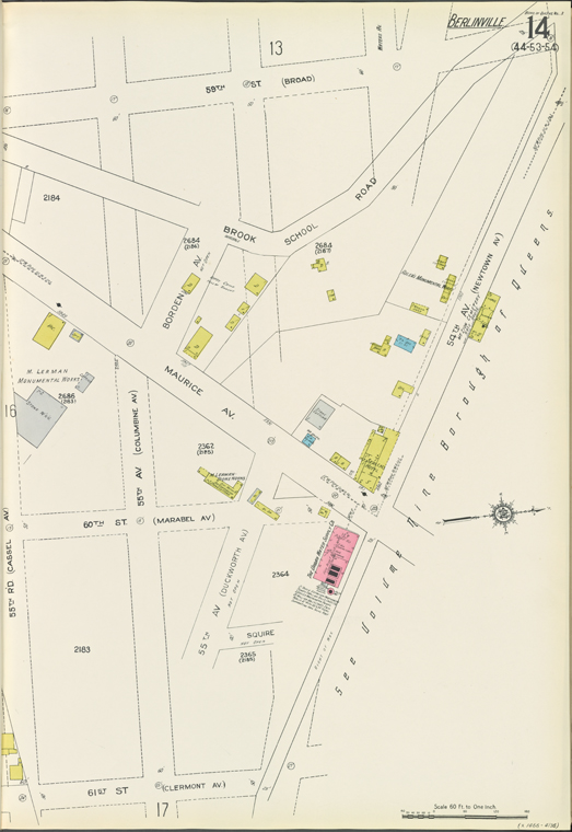
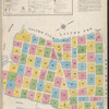
![Queens V. 3, Plate No. 14 [Map bounded by 59th St. (Broad), 54th Ave. (Newtown Ave.), 61st St. (Clermont Ave.), 55th Rd. (Cassel Ave.)]](https://images.nypl.org/index.php?id=5096618&t=b)
Lionel Pincus and Princess Firyal Map Division, The New York Public Library. "Queens V. 3, Plate No. 14 [Map bounded by 59th St. (Broad), 54th Ave. (Newtown Ave.), 61st St. (Clermont Ave.), 55th Rd. (Cassel Ave.)]" The New York Public Library Digital Collections. 1936. https://digitalcollections.nypl.org/items/f611bad0-7fb3-0131-f092-58d385a7bbd0
Lionel Pincus and Princess Firyal Map Division, The New York Public Library. "Queens V. 3, Plate No. 14 [Map bounded by 59th St. (Broad), 54th Ave. (Newtown Ave.), 61st St. (Clermont Ave.), 55th Rd. (Cassel Ave.)]" New York Public Library Digital Collections. Accessed February 9, 2025. https://digitalcollections.nypl.org/items/f611bad0-7fb3-0131-f092-58d385a7bbd0
Lionel Pincus and Princess Firyal Map Division, The New York Public Library. (1936). Queens V. 3, Plate No. 14 [Map bounded by 59th St. (Broad), 54th Ave. (Newtown Ave.), 61st St. (Clermont Ave.), 55th Rd. (Cassel Ave.)] Retrieved from https://digitalcollections.nypl.org/items/f611bad0-7fb3-0131-f092-58d385a7bbd0
<ref name=NYPL>{{cite web | url=https://digitalcollections.nypl.org/items/f611bad0-7fb3-0131-f092-58d385a7bbd0 | title=
(cartographic)
Queens V. 3, Plate No. 14 [Map bounded by 59th St. (Broad), 54th Ave. (Newtown Ave.), 61st St. (Clermont Ave.), 55th Rd. (Cassel Ave.)], (1936)
|author=Digital Collections, The New York Public Library |accessdate=February  9, 2025 |publisher=The New York Public Library, Astor, Lenox, and Tilden Foundations}}</ref>
![Queens V. 3, Plate No. 14 [Map bounded by 59th St. (Broad), 54th Ave. (Newtown Ave.), 61st St. (Clermont Ave.), 55th Rd. (Cassel Ave.)]](https://images.nypl.org/index.php?id=5096618&t=t)