Click to visit the main New York Public Library Homepage
The New York Public Library
Digital Collections
About Digital Collections
Browse
Search only public domain materials
Items
Collections
Divisions
Home
Search
Browse
About
Search only public domain materials
Items
Collections
Divisions
Digital Collections
Using Images
Using Data
Search
Filtered search
Show filters
Hide filters
Show Only Public Domain
topic
Harbors
2
Canals
1
Channels (Hydraulic engineering)
1
Hydrographic surveying
1
Nautical charts
1
More
Less
name
x
Williams, W. G. (William G.), -1846
United States. Army. Corps of Topographical Engineers
3
Drayton, T. F., Lt
1
Franklin, William Buel, 1823-1903
1
Gunnison, J. W. (John Williams), 1812-1853
1
More
Less
collection
Maps of New York City and State
3
Maps of North America
3
place
New York (State)
3
Erie, Lake
2
Niagara River (N.Y. and Ont.)
2
Buffalo (N.Y.)
1
Chautauqua Creek (N.Y.)
1
More
Less
genre
Maps
6
Bathymetric maps
2
Nautical charts
1
Road maps
1
publisher
U.S. Army Corps of Topographical Engineers
1
U.S. Congress
1
United States Army Corps of Engineers
1
United States House of Representatives
1
publisher not identified
1
More
Less
division
Map Division
6
type
cartographic
6
Date Range
to
6 results found
Filtering on:
x
Name
: Williams, W. G. (William G.), -1846
Sort by:
Title
Date created
Date digitized
Sequence
Chart of Green Bay
Map of Presqu'ile Bay or Erie…
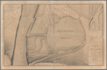
Survey for a ship canal aroun…
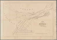
Map of the vicinity of Buffal…
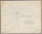
Cataraugus harbor and the pub…
Map of reconnaissance exhibit…